Cheaha Wilderness Backpacking – March 2021
Cheaha Wilderness Backpacking – March 2021
2
JUNE, 2019
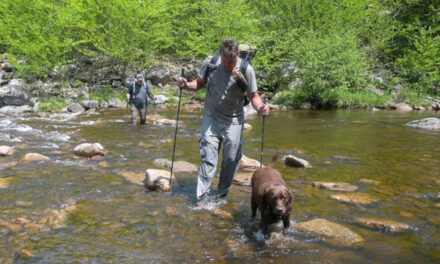
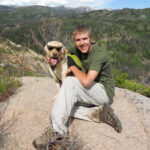
In March 2021, I joined Carl and Travis for a 3-day, 20-mile hike in the Cheaha Wilderness of Alabama. It’s an area that I’ve long wanted to hike. When planning my 2018 hiking agenda, the Cheaha Wilderness was going to be my first hike of the season. Ultimately, I decided the ten-hour drive was too long. Red River Gorge became my first hike of the 2018 season instead. In March 2019, I met Carl for the first time when we did a hike together. Carl is from Alabama, and our original plan was to hike in the Cheaha Wilderness. Ultimately, we decided to do that March 2019 hike in Savage Gulf State Natural Area in Tennessee. There would be no change of plans this time. I would finally experience a Cheaha Wilderness hike. My two Labs, Jaden and Bailey, joined us for the Cheaha trip.
First hike with my new Zpacks Arc Blast backpack

This hike would be my first with my new Zpacks Arc Blast pack. This Arc Blast was the second I’ve owned. I bought the first one in 2015, which served me well until June 2019. One of the shoulder strap mounting points tore through before the 2019 Yellowstone hike. I tried getting by with an REI Flash 55 pack but decided to return to the Arc Blast. I was excited to see how it would perform.
Meeting Travis in Fort Payne, Alabama – a very long drive
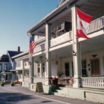
The plan was to meet Travis in Fort Payne, Alabama, and then meet Carl at the Cheaha Wilderness trailhead the following morning. It is an eight-hour drive from my home in Indiana to Fort Payne. And it’s another two hours from Fort Payne to the trailhead. Long drive, indeed! But one significant positive is that we were hiking ‘down south.’ The temperatures would be in the low 70s for our hike compared to the 30s I’d left up north. I found Fort Payne to be a throwback type of town. It has a picturesque downtown area complete with an old-style single-screen theater. It reminded me of small-town America in the 1950s, before big-box retailers crushed many of these downtowns.


Fort Payne is home to the band Alabama and Sally’s BBQ


While I waited for Travis to arrive, I explored what Fort Payne had to offer. Carl had mentioned that Fort Payne was the home to the band, Alabama. He told me there was a park with a monument to the band. The band started in Fort Payne in 1969 under the name Wild Country which they changed to Alabama in 1977. Their greatest success came in the 1980s when they had 21 number-one songs. I found Sally’s Smokin’ Butt BBQ a few miles south of town. I love a good barbeque place the night before a hike, and Sally’s didn’t disappoint. As we walked up to the restaurant the smell of smoked meat was amazing. The brisket and pulled pork were fantastic. Some nights they serve smoked prime rib, but not the night we were there. Too bad!
Meeting Carl at Cheaha State Park – hiking begins
After a beautiful drive on the Skyway Mountainway, we met Carl at Cheaha State Park. The State Park is home to the highest point in Alabama. Our hike was going to be ‘up high,’ by Alabama standards. It was a short 1/2-mile drive from the State Park down to the Pinhoti Trail Cheaha trailhead. Our plan for the hike was to hike south the entire first day on the Pinhoti Trail to the intersection with the Odom Trail – about six miles total. On the second day, we’d cross over the ridge on the Odom Trail and then turn north on the Nubbin Creek Trail. The Guthook app (now called ‘Far Out’) had information on the Pinhoti Trail, so we had data on campsites and water sources for day 1. We had no such data for day 2.


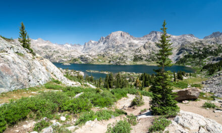
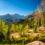
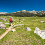
Hiking south on the Pinhoti Trail – great ridge top views


The hike started by passing through an ornate gateway. The weather was perfect, and passing through that colorful gateway under clear blue skies put everyone in a great mood. From the trailhead, we climbed steeply uphill about 1/2 mile to the intersection with the Pinhoti Trail. The Pinhoti Trail extends 337 miles, from southeastern Alabama to the Benton McKaye trail in northern Georgia. From there, a hiker can connect with the Appalachian Trail. The blaze of the Pinhoti is distinctive – a Turkey track. The hike was along a high ridge with unending views of the Alabama countryside below. It was a little sketchy with the dogs in spots, but we kept a close eye on them.

1972 Plane crash site on trail to McDill Point
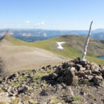
About 2.5 miles into the hike, we came to McDill Point ridge. The Pinhoti Trail doesn’t go all the way out to the Point, but there is a short side trail that will take you out to it. On that trail, a short distance south of the Pinhoti, is a 1972 airplane crash site. Carl had researched the crash before the hike and brought the NTSB crash report. Carl read the information to us as we stood somberly looking at the wreckage. The flight took place at night on December 31, 1972. The pilot was not instrument rated and continued as the weather deteriorated. The NTSB describes that sort of crash as ‘controlled flight into terrain.’ They flew into the mountain while in the clouds. Four people died in that crash. Knowing that made being there surreal.


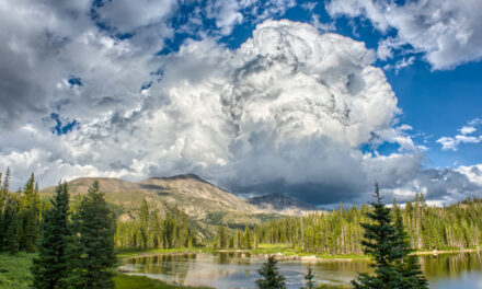
More great views and a brutal rocky stretch of trail


At McDill Point, the trail turned sharply to the north and soon wound around a canyon of sorts to head back south. We stopped for lunch at a pretty spot in the woods on the eastern side of that ‘horseshoe bend.’ The site had a decent view of McDill Point though you had to look through the woods to see it. After lunch, we headed straight south on the Pinhoti towards our intended campsite at the intersection with the Odom Trail. The hike was again along the ridge, and the views were incredible. There wasn’t a cloud in the sky, and the visibility was limitless. In the distance, we watched as some wildfire grew all day. Just before camp, we encountered a one-mile stretch of trail entirely on unstable rocks. It was brutal and exhausting.
First Cheaha Wilderness camp – gorgeous sunset
The first day had been very warm, and there had been no water on top of the ridge we hiked all day. With that brutal stretch of rocks slowing our pace and increasing our workload dramatically, we were all very thirsty when we got into camp. Fortunately, there was a nice stream right next to our campsite. It was the first water we had seen all day. Our site was large and relatively open. It gave us a great view of the spectacular ridgetop sunset that evening. Carl got a fire going. Our appetizer was Packit Gourmet cheddar cheese spread. For this trip, we had planned ‘real’ food for dinner each night. Tonight it would be hot dogs roasted over the fire. They were great!


Hiking in the Cheaha Wilderness on day #2


It was surprisingly chilly the second morning. Carl made some dog friends when he prepared some shelf-stable bacon. I enjoy few smells more than bacon and fresh-brewed coffee when you’re out in the woods. Carl made Travis and me very happy too when he shared the bacon with us! The hike started with a climb on the Odom Trail to the other side of the ridge we had been on. Unfortunately, we had no trail knowledge or information for the second day. There were few campsites and no water sources. Fortunately, we met a group going the other way on the Nubbin Creek Trail. They told us of a camp just ahead with water nearby.
Fortuitous Cheaha Wilderness camp on the ridge


The lack of trail information made the second day of hiking uncomfortable. We weren’t overly concerned because we knew we could hike back to the cars if we had to. But having no information about potential campsites and water sources was unsettling. Aside from a few day hikers close to the trailhead and one at the plane crash site, we hadn’t seen any other people the entire hike. Running into that group when we did was a mini-miracle. They came along at just the right moment! There is a backpacking saying, “the trail always provides.” It certainly did in that situation. The camp was on a ridge with a great view of the surrounding countryside. It was a very nice site, but it was exposed, windy, and very chilly once the sun set.
Spam ‘tree’ over the fire
Spam was on the menu for dinner the second night. It’s not something I ever eat at home, but it’s excellent in the backcountry. The combination of saltiness and smoked sausage, ham, and bacon flavors is the perfect taste sensation after a long day of hiking. Carl always takes special care in sculpting the ideal Spam ‘tree’ stick. Once the stick is ready, each branch is loaded with multiple slices of Spam tasty goodness. Our ridgetop campsite was welcome and it had a great view. But with no leaves on the trees, it was completely exposed to the constant, reasonably strong breeze. When the sun set, the temperature plummeted. It was cold! We kept getting closer and closer to the fire for warmth until we were almost standing in it!


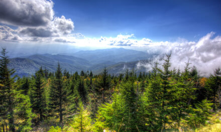
Cold morning in the Cheaha Wilderness – hiking back to cars


The weather on our third and last day was perfect again. But it was cold! The temperature was near 40deg, and a steady 15-MPH breeze blew. The combination led us to pack up camp quickly and start hiking so that we could generate some exercise-induced heat. The last day’s hike was only three miles along the Cave Creek Trail. We were on the other side of the ridge from our route yesterday, but the views were again outstanding. Not the wide-open vistas from the first day, but still very nice. The hiking was easy, with very little climbing or descending. Once the sun came up, the temperature climbed, and it was very comfortable. Soon we were walking through the same gate that had started our hike.
Conclusion – Cheaha Wilderness Backpacking
The Cheaha Wilderness provided us with a great winter hike. Aside from that rocky section of trail on the first day, all the trails were smooth and relatively gently graded. The views were outstanding, especially on the first day. There weren’t many campsites and even fewer water sources, but if we were to go back we would know that situation going in. I just wish the Cheaha Wilderness was a little closer to Indiana! If I find myself in that area for other reasons I would definitely do another hike there. But when you have destinations like Great Smoky Mountains National Park many hours closer, it’s doubtful I’d drive that far to make a special trip. But I am glad I made this trip because it was a great hike with Carl, Travis, and the dogs.