Savage Gulf State Natural Area Backpacking – March 2019
Savage Gulf State Natural Area, Tennessee – March 2019
23
MARCH, 2019
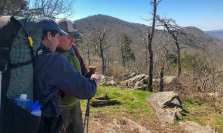
Bridges… that is what will always remind me of the March 2019 Savage Gulf State Natural Area hike. Specifically, swinging suspension bridges. You see, my old yellow Lab, Jaden, REALLY dislikes swaying bridges. And Savage Gulf had more than its fair share of bridges. It made for some creative bridge-crossing techniques. But Savage Gulf also has fantastic, well-maintained hiking trails, great campsites, eye-popping views, and spectacular scenery. It was my first time hiking that area of Tennessee and my first backpacking trip with Carl.

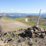
Looking east down Savage Creek Valley from North Rim Trail
“Had a great backpacking trip around the entire park. Four days of hiking and every second was filled with the gorgeous outdoors. Campsites were clean and very reasonably priced for overnights. Must recommend to anyone looking for a great hiking location.“ – Will Cook
Where is Savage Gulf State Natural Area?

Description of Savage Gulf State Natural Area
Savage Gulf is a 15,590-acre natural area located 25 miles northwest of Chattanooga, Tennessee. Carved like a giant crowfoot into the western edge of the Cumberland Plateau, Savage Gulf State Natural Area is one of Tennessee’s most scenic wilderness areas. Its sheer sandstone cliffs and rugged canyons provide extraordinary views. A significant feature is Stone Door, a 10 ft. wide by 100 ft. deep crack, forming from the top of the escarpment into the gorge below. Breathtaking waterfalls form at the head of many gorges, where streams drop off over hard sandstone cap rock. Many big streams go underground cutting through shale and limestone to form dry creek beds. The hiking trails generally run along the edge of the canyon rims or along the creeks on the bottom. Transitioning between the rim and the creek bottoms is on steep, rocky trails.

Traveling from Indiana to Savage Gulf
Drive to Manchester, Tennessee


The nearest ‘big’ city to Savage Gulf is Manchester, Tennessee, located about an hour’s driving time northwest of Chattanooga. Manchester attracted my attention because it had a selection of hotels and restaurants. The drive down was in typical early Spring ‘grunge’ weather, but everything went smoothly. The forecast for the Savage Gulf area during our hike was good for March. No rain was expected and temperatures would be in the 60s. I wasn’t traveling alone for this trip. My two labs, Jaden and Bailey, were joining me. The doggies seem to ‘light up’ with joy when they get to join me for a backpacking trip. This would be my first hike with Carl, and I’d meet him the next morning at the trailhead.
Rodeway Inn and Suites in Manchester
When you travel with two dogs, your lodging choice can sometimes be limited. My hotel search always starts with ‘dog-friendly hotels’, and then I take it from there. After I find my list of hotels that welcome dogs, it comes down to good reviews, low price, and, above all, clean. Any mention of ‘dirty,’ ‘bugs,’ etc., and that hotel is scratched from the search. My search led me to the Rodeway Inn and Suites in Manchester for this trip. It was by no means my ‘best’ option, but it was the cheapest. In this case, $65 per night. That is the lowest price I have ever paid for a room with the dogs. Part of my rationale for choosing the Rodeway was to see just how far I could push the budget ‘envelope.’ The hotel was just ‘ok,’ but it was clean and gave us a bed for the night.


J&G Pizza and Porky’s Pit BBQ


After getting settled into the room, our priority became dinner. OK, the dogs were probably way ahead of me on that! I was in the mood for pizza. It didn’t take much searching to discover J&G Pizza and Steak House. Right up there in terms of top priority was finding a place to walk the dogs. As luck would have it, Google maps indicated that right across the street from J&G was a park with a large, secluded grass field. Perfect! We piled back in the car and headed through downtown Manchester towards J&G Pizza. Nailing the trifecta was spotting Porky’s Pit BBQ right next to the J&G. Pizza, barbeque, and a great dog walking spot… all within 100 yards of each other. Doesn’t get much better than that the night before a hike.
Savage Gulf Hike Plan
The first morning of hiking started with a breakfast sandwich from my beloved Waffle House. Fortuitously, it was located 100 yards from the hotel room door. After breakfast, the first order of business was meeting Carl at the Savage Gulf North Trailhead, an hour’s drive from the Rodeway. We planned to do a 3-day, 2-night, 21-mile point-to-point hike starting from the Savage Gulf East Trailhead. Our hike would end at the North Trailhead. We would leave my car there, pile dogs, people, and gear into Carl’s truck, and drive to the East Trailhead to start the hike. The first day would be seven relatively easy miles on the North Rim Trail to our first camp at Hobbs Cabin. Our second day would be ten gnarly miles on the Connector Trail to Alum Gap Camp. The last day would be a flat and easy four miles to the North Trailhead.


Day #1 – Savage Gulf State Natural Area Backpacking
Meeting Carl, Shuttling Cars, and start of the hike
Unlike the weather during the drive down, our first day of hiking was glorious. Clear skies, sunshine, and crisp temperatures in the 40s. The forecast indicated good weather for our three-day hike, with highs in the upper 60s. It doesn’t get much better than that for early Spring backpacking. The drive from Manchester to the Savage Gulf North Trailhead went smoothly. Terrain on the drive was gently undulating until I was within ten miles of the trailhead. Then the road went steeply uphill on switchbacks. The transition was a wake-up call regarding the hiking conditions we could expect. As I pulled into the trailhead parking lot, I immediately saw Carl’s truck – it stood alone in the lot! We wouldn’t be fighting off crowds of other hikers. My Saab was left in the parking lot, and we drove to the East Trailhead to start the hike.

Group picture in Savage Gulf East Trailhead parking lot before the hike
Savage Gulf Day Hike Trail – Tornado Damage and First Bridges
From the East Trailhead, our hike started on the Savage Gulf Day Loop Trail. It would take us two miles to the North Rim Trail, which we would then hike the six miles to Hobbs Cabin. We immediately started seeing signs of significant tornado damage. I didn’t know it then, but the carnage had been caused by an EF-1 tornado that had ripped through the area only four months early (in November 2018). Fortunately, and amazingly, the trails had already been ‘cleared’ in a tunnel-like manner. It was surreal hiking, and it impressed me with the efforts of the Friends of South Cumberland group that helps maintain Savage Gulf. They had cleared the trails. We soon came to the first suspension bridge. It would not be the last!


Tornado damage on Sagage Gulf Day Loop Trail, near East Trailhead
YouTube Video – Recent Tornado Damage at Savage Gulf
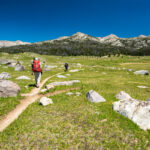
North Rim Trail


Hiking on the North Rim Trail reminded me of Red River Gorge and Big South Fork. It was beautiful, with excellent cliff-top views of Savage Creek far below. One downside was the two inquisitive trail dogs I was hiking with. Carl had a nasty habit of walking to the cliff edge to get a better look hundreds of feet straight down. I said ‘no thank you!’ to that. But the doggies are always curious to see what the humans are up to and would follow Carl out towards the abyss. I love that type of cliff-top hiking, but I don’t like the thought of watching a dog go over the edge. My vigilance and anxiety were at peak levels along that stretch of the North Rim Trail. Fortunately, there were sections of the trail that would head inland, easing the tension.

North Rim Trail overlook – the trail ran along the edge of the cliff
Tanking up on Water Before Hobbs Cabin
Two miles before Hobbs Cabin, we came to a small creek crossing. It was the third and last creek crossing since we started hiking on the North Rim Trail. Just before we came to the creek, we met a group hiking in the opposite direction. It was a fortuitous meeting. They had stayed at Hobbs Cabin the night before and informed us that the water source was ‘less than ideal’ (a.k.a. downright nasty). They suggested we tank up on all the water we would need at the stream we were approaching. We took their advice and cameled up on six liters of water each. That was the minimum I would need for myself and two thirsty dogs. It also meant that the last two miles of the hike would be done carrying 13.2 extra pounds of water!


Great First Night of Savage Gulf Hike at Hobbs Cabin


Campsites at Savage Gulf are tightly controlled. You need to make a reservation in advance here, and the reservation is for a specific site at a specific campground. Of all the National Parks and other backcountry areas where a permit had been required, this is the first time I’ve experienced it at the specific site level. In a way, it was nice. We knew precisely where we would stay that night. The Hobbs Cabin campground has eight campsites. All of them appeared to be nice. They were large and spaced out, so there was privacy. We had campsite #2, close to the cabin. You can also stay in the Hobbs Cabin for a historical experience. It was a beautiful clear night. We had a great fire, and the view of the stars above was wonderful.

View looking straight up from our log seat at Hobbs Cabin camp
Day #2 – Savage Gulf State Natural Area Backpacking
Morning at Hobbs Cabin camp – preparing for the Connector Trail
Day #2 continued the great weather trend. There wasn’t a cloud in the sky. But the clear skies brought in the chill, and both Carl and I put on fleece layers to ward off the cold. The dogs like nothing better than waking up in the woods, and after their breakfast, they were anxious to get going. I was using my trusty old Nemo Meta 2P tent for this trip. It still looked great but showed signs of its 10-year-old age. I had been researching dog-friendly replacement shelters, and Carl conveniently had the exact Zpacks Plex shelter I’d had my eyes on. It gave me a chance to take a close look at it. Hobbs Cabin sits about 1/4-mile off the main trail, and the campsites are even back. After packing everything, we walked past the cabin heading out for a long day on the Connector Trail.


Hobbs Cabin
Introducing the Connector Trail – steep downhill to Savage Creek


We turned right onto the Connector Trail a hundred yards after returning to the main trail. Aside from the last two miles to camp, our entire second day would be on the Connector Trail. It didn’t take long to understand the ‘character’ of the trail. It was going to be a tough, long day! As we transitioned off the plateau we had been on all day #1, the trail descended steeply down the cliff toward Savage Creek. Not only was the trail steep, but it was also nearly entirely rock covered. It was rough hiking for humans but brutal for the dogs. They had trouble placing their paws on the tops of the rocks and would slip down into the cracks. I was fearful the dogs would get injured. It was slow, exhausting, and nerve-rattling.

Connector Trail downhill toward Savage Creek to start day #2
The First (of many) Suspension Bridges
As we approached the bottom of the descent, Savage Creek came into view. The trail crossed Savage Creek on a relatively long and high suspension bridge. We had encountered ‘mild’ bridges on the first day, and it was clear Jaden didn’t want anything to do with them. Coaxing him gently across worked on day #1, but it would take a lot of work on the second day. Fortunately, the first bridge over Savage Creek had fencing along both sides. The fence prevented Jaden from slipping off the sides. I got him across that first bridge by grabbing his collar and pulling him forward. The bridge swayed badly as I crossed. It was bad enough crossing as a solo human, but it was treacherous with a reluctant dog. I was completely out of breath afterward.


Suspension bridge over Collins River near Sawmill Campground
Bridges, bridges… and more bridges
I lost track of how many bridges we crossed, but it was at least five after the first one. We crossed the Collins River just after the Sawmill Campground. Then two more crossings of Savage Creek. Finally, a couple more bridges on unnamed creek crossings as we traversed the cliff face above Savage Creek. I tried every technique possible – carrying Jaden, pulling, pushing, and simply begging. Nothing really worked. It started to make me feel bad that I’d gotten him into the situation. Bailey didn’t mind the bridges at all, and she seemed to look at the challenges with Jaden as simply big fun. Finally, we crossed the last bridge and reached the intersection with the Big Creek Gulf Trail that would take us up the hill to the Stone Door.


YouTube Video – Suspension Bridges of Savage Gulf
Steeply uphill to the Stone Door


That climb from Savage Creek to the Stone Door was ‘memorable.’ In a brutal sort of way. We had already hiked seven difficult miles over the last four hours when we looked up at what we would be facing for the final big climb of the day. It was an intimidating sight. Our legs were toast, and we were exhausted. Not just from the constant up and downs on rocky trails but also from the challenge of many bridge crossings with a skittish dog. The good news was it was less than a mile to the top. The bad news was the Stone Door was 700 vertical feet above our perch on Savage Creek. Knowing the climb wouldn’t happen without some effort, we got started. It was a relentless 1000-foot-per-mile grade, but we made it to the top in 40 minutes.
The Stone Door
At the top of the climb, we encountered a series of wooden stairs. It wasn’t clear where the trail would take us after the stairs. I thought we would make a left turn, but when we reached the top step, I looked to the right and was stunned to see the entrance of the Stone Door. The Stone Door is a six-foot wide by 100-foot long crack in the rock face. It looks like a giant door left ajar. The Stone Door has been used for centuries for people and animals to get up and down over the bluff. It’s also rumored that bison used it when they inhabited the Cumberland Plateau before the mid-18th century. I didn’t relish the idea of hiking up another 100 or so steep steps, but I also knew the tough hiking was done for the day once we reached the top.

YouTube Video – Climb from Savage Creek and Stone Door
Sketchy Rest Spot at the Top of the Stone Door


You could turn left at the top of the Stone Door and head down the Big Creek Rim Trail to the Alum Creek Campground, where we would spend the night. We turned right. What attracted our attention was a spectacular view spot that overlooked the Big Creek Valley. It was also the sketchiest spot for dogs we encountered on the entire hike. An entirely exposed rock shelf opened before us. The east and south edges of the shelf went straight down 600 feet to Big Creek below. I stayed back a healthy distance from the edge. Carl decided to take a closer look, and the dogs joined him. Fortunately, no one got too close, and all worked out fine. The overlook offered a perfect view of the route we had hiked all day.

Looking up Big Creek Valley to the northeast from the top of Stone Door
Alum Gap Camp site #8
After our time at the Stone Door, we still had 3.2 miles of hiking to get to the Alum Gap Camp and our ‘home’ for the last night. Our legs were cooked, but fortunately, the hike along the Big Creek Rim Trail was flat. Even with roasted legs, our pace was fast, and it took a less than an hour to get to campsite #8 at Alum Gap. Unlike our peaceful experience at the Hobbs Cabin camp, the Alum Gap Camp is a popular overnight party spot. It’s just a mile from the closest parking area, and partiers take full advantage of the proximity. It feels like car camping because it is. Like the Hobbs Cabin, the campsites were large and spaced out well, but the noise and party atmosphere took away some of the enjoyment of our last night.


Enjoying the campfire the last night at Alum Gap Camp site #8
Day #3 – Savage Gulf State Natural Area Backpacking
Last morning of Savage Gulf hike – Alum Gap campsite #8


Our last day at Savage Gulf started with clear skies and crisp, cold air. It had the feel of early spring, with temperatures in the upper 30s. Sleep had been hard to come by as the party crowd stayed up well past ‘hiker midnight.’ Ultimately, it was more amusing than annoying, so all was good. Some hot Dunkin Donuts coffee tasted great in our cold camp, and it helped the heart going. Breakfast was simple and quick – Honey Bunches of Oats with Nedo instant whole milk powder. Jaden and Bailey joined me for breakfast, but it didn’t take them long to figure out there would be few handouts with my choice of cereal for breakfast. There were smiles all around, knowing we only had three miles of easy hiking to get back to the car at the Savage Gulf North Trailhead.

Author and Bailey at Alum Gap Camp, on the last morning before hiking
Three miles on the Laurel Trail to Savage Gulf North Trailhead
We packed up quickly and hit the trail early. There was a bounce in our steps, knowing it was less than an hour back to the car. Almost as soon as we started hiking on the Laurel Trail, we came to an old moonshine still site. I always love coming upon those historical spots in the backcountry, no matter how small. It adds variety to the often hypnotic monotony of hiking. The Laurel Trail was mildly undulating with no significant ups or downs. It reminded me very much of hiking in Indiana in early spring. The blazes were 2″X6″ white metal plates nailed to trees – identical to the iconic blaze of the Appalachian Trail. Our pace was fast – roughly four miles per hour. In what seemed like no time at all we were hiking into the North Trailhead parking lot.


Carl, Jaden, and Bailey in the Savage Gulf North Trailhead after the hike
Conclusion – Savage Gulf SNA Backpacking 2019
The Savage Gulf North Trailhead parking lot was empty when we finished our hike. There was one car in the lot – Carl’s! Aside from the one lucky encounter we had with a group of hikers on the first day (Hobbs Camp water situation), we didn’t see any other hikers the entire three days. There were two groups besides us camping at Hobbs Cabin and many at Alum Gap Campground, but that was it. Overall, we had the trails of Savage Gulf to ourselves. I loved our hike at Savage Gulf State Natural Area. It is an area that receives much love from the Friends of South Cumberland. Trails were well marked and maintained, the campsites were excellent and in great condition, and it’s a beautiful area with great views and scenery. I highly recommend adding Savage Gulf to your list of potential backpacking destinations.

Group shot at Alum Gap Camp