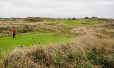
Rocky Mountain NP Backpacking – Sept 2016
Grand Lake, Colorado – September 2016
7
SEPTEMBER, 2016
2015 and 2016 had been the pinnacle of my backpacking career thus far. Starting with my first truly successful Colorado hike, the 2012 South San Juan Wilderness trip, by the end of 2016, I had done five Colorado hikes, two Glacier National Park hikes, a Sierra Nevada hike, and many hikes in the Midwest and East. But I had never done a hike in Rocky Mountain National Park, and it had been on my bucket list since the beginning. In September 2016 I finally checked it off my ‘list,’ tackling the Continental Divide Trail Loop hike out of Grand Lake.
Travel to Grand Lake, Colorado
Where is Grand Lake, Colorado?

Flying to Denver and drive to Grand Lake


Dogs aren’t allowed in the backcountry of Rocky Mountain National Park, and Christian was busy working in Boulder, so it would be a solo trip. Jaden and Bailey weren’t happy, but taking them along wasn’t an option. Unlike many of my flying/driving trips from Denver, the driving portion of this trip was reasonable. That meant I could forego the ‘oh-dark-thirty’ morning flight and leave at a more suitable time. It was a beautiful day in Indianapolis and Denver, and the flight was on time and smooth. My pack arrived at baggage claim, picked up a rental car, and started the three-hour drive to Grand Lake. A mid-morning arrival meant traffic was light. The views as I went over Berthoud Pass were fantastic and got me excited to hike.

Driving over Berthoud Pass on US-40
Picking up my permit at the RMNP Wilderness Office
I drove straight to the Wilderness Office to pick up my permit. My goal was to change the first night camp closer to the climb up to Bighorn Flats. The advance permit had me staying at Grouseberry, making the second day long and the first short. I was hoping for North Inlet Junction or July. Unfortunately, neither option was available. The Ranger briefing indicated lightning storms were occurring on the Bighorn Flats daily. Oh joy!


2016 Rocky Mountain National Park CDT Loop Hike Plan
My plan for the 2016 Rocky Mountain National Park CDT Loop hike was straightforward. The hike is a kidney-shaped loop starting at the North Inlet Trailhead just north of Grand Lake. Except for the final leg on the western side, the entire hike is on the Continental Divide Trail. Total hiking distance is 27 miles. My permit showed 3 nights and 4 days, but if everything went well, I planned to shorten the hike to 2 nights/3 days. Campsites would be Grouseberry night #1, Granite Falls night #2, and Green Mountain night #3. It was only eight miles from Granite Falls to the trailhead, so I intended to skip the third night at Green Mountain. The highlight would be day #2. That day would start from Grouseberry, then over Flattop Mountain and the intimidating Bighorn Flats, to Granite Falls. Twelve hiking miles and 3000 feet of elevation gain.

Exploring Grand Lake the night before hiking
Aspens in fall color by Rocky Mountain NP entrance


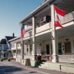
For my night in Grand Lake before the hike, I decided to stay in a rustic cabin that was part of the historic Grand Lake Lodge complex. After obtaining my permit, I headed over to see if I could check-in. Near the side road that took you into the Lodge area was an entrance sign for Rocky Mountain National Park. I pulled over to grab a few pictures and get a selfie in front of the sign. Directly across the street was a gorgeous aspen grove in its full-on yellow fall color. It was a beautiful blue sky, sunny, puffy white cloud Colorado day, and the contrast of colors was stunning. I walked across the street from the park entrance sign, soaked in the vibrant colors and gentle rustling of the aspen leaves in the breeze. It was relaxing and enjoyable.

Rocky Mountain National Park entrance sign near Grand Lake Lodge
Grand Lake Lodge
When looking into pre-hike lodging options for my night in Grand Lake, I was shocked to find few vacancies. And the available rooms were $300 and up. Ouch! But then it dawned on me that I was arriving on the Sunday of Labor Day weekend. In the US, Labor Day is the ‘last hurrah’ of summer for families with kids returning to school. Fortunately, I stumbled upon the historic Grand Lake Lodge. They had a ‘cabin room’ available for $135. It turned out to be more of a ‘duplex’-type cabin, and the room was sparse and rustic, but it served its purpose. The Lodge was opened in 1920 and has an interesting history. It’s located up the hill from Grand Lake, and the views from the Lodge porch, and even parking lot, are the best you’ll see.


View of Grand Lake from the parking lot of Grand Lake Lodge
YouTube Video – Travel to and pre-hike time in Grand Lake
Rocky Mountain National Park CDT Loop Hike Day #1
Tonahutu Creek Trail and North Inlet Trail trailheads


When I picked up my permit, I asked the Ranger about trailhead parking. He said it would get busy by mid-morning and recommended I arrive early to ensure parking spots were available. My arrival at the Tonahutu Creek-North Inlet Trailheads was before 7 AM. A few cars were in the lot, but there were many open parking spots. Then I noticed an overflow lot a short distance away. It was empty. There are actually two trailheads in the vicinity – Tonahutu Creek and North Inlet. You came to Tonahutu Creek first, but there’s no parking there. All the parking was at the North Inlet Trailhead. I had time, so I drove the short distance into Grand Lake and bought a breakfast sandwich at the Egg and I.

Tonahutu Creek Trail – North Inlet Trail trailheads
“Within National Parks is room – glorious room – room in which to find ourselves, in which to think and hope, to dream and plan, to rest and resolve.” – Enos Mills, “Father” of RMNP
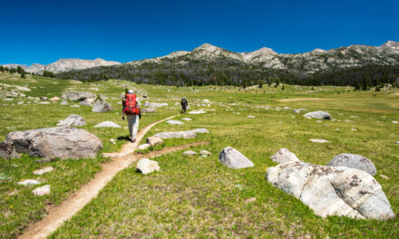
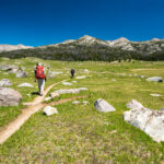
Flat, fast morning hike into the rising sun on the North Inlet Trail
It was seven miles from the trailhead to my first camp, Grouseberry. At the pace I started, I would arrive by 9:30 AM! The trail was gently graded (uphill), perfectly flat, smooth, and wide. It looked more like a forest road than a trail. On my left was Nisa Mountain, and off to the right in the distance was Enentah Mountain. Once the trail turned north, I would hike between those two mountains as they closed in on the trail. For now, the hike was through pleasant, flat meadows. I passed a group of horses lazily enjoying the morning in a log-fenced field. The scene could have been from the 1800s. A mile into the hike, the trail turned north along North Inlet. My pace had been fast but would soon slow as the grade steepened.


North Inlet with Enentah Mountain to the right
My first glimpse at Rocky Mountain National Park campsites


As I passed a series of campsites, the trail began to narrow and steepen. Summerland Group, Summerland Park, and Twinberry. I stopped at each to take a quick look, thinking my night at Grouseberry would be in a similar setting. They were all the same – located a short distance from the main trail in somewhat open evergreen trees, well-worn tent pads, and a nearby water source. September hiking meant the sun was low in the sky and shadows were long. All the hiking had been generally straight into the sun, so getting decent pictures was a struggle. The weather was ideal for hiking – clear skies, low humidity, temperature in the 70s, and no wind. Fall colors and somewhat open views made it even more pleasant.

North Inlet Trail passing between Nisa Mountain and Mount Enentah
North Inlet Trail steepens at Cascade Falls Point

As I approached the first significant landmark of the hike, Cascade Falls, the trail steepened. But ‘steepened’ didn’t mean painfully so. The grade was at most 400 feet per mile. In the area that would have been tougher, a steep hillside directly above the Falls, they had carved gentle rock ‘stairs’ into the trail. I was impressed! But Cascade Falls itself was disappointing. It was more of a stream passing over large boulders than a ‘waterfall.’ Shade cover made the pictures I took flat and dull. Thankfully, I came upon a stunning meadow of fall-yellowed grasses at the top of the climb after Cascade Falls. Winded from the climb and high altitude, I decided to take my first lengthy break at the meadow. Re-hydration was my priority in the bone-dry, jerky-transforming air.
After the uplifting meadow, there was one more steep section before the trail leveled out for good approaching the Grouseberry Campsite. I passed a landmark called Big Pool and the adjacent Big Pool campsite. Like Cascade Falls, low-angle sunlight meant shaded scenes and bad pictures. I skipped the short side trail to the campsite and was satisfied with a picture of the camp marker. From Big Falls, it was just over a mile to my home for night #1 – Grouseberry CG.


Beautiful sunlit meadow with yellow fall-colored grasses after Cascade Falls
Early arrival at Grouseberry Campground


The trail ascended just 200 vertical feet in the mile-and-a-half from Big Falls to Grouseberry. Barely noticeable as an incline. Combined with open, yellow-grass meadows, views of the lower slopes of Ptarmigan Mountain, and alongside North Inlet, my final steps for the day were pleasurable. I came to a relatively sizeable unnamed pond in yet another meadow a few hundred meters from Grouseberry. Passing quickly, I made a mental note that I would return to the pond later for some leisure time and, hopefully, wildlife sightings. Elk, deer, and bear would think that pond area a paradise. Within a few minutes, I arrived at Grouseberry. It was 10:30 AM! I set up my Zpacks shelter in a cluttered area of downed trees.

Camp at Grouseberry Campground on night #1
YouTube Video – Hike from the North Inlet Trailhead to Grouseberry CG
Killing time
Side excursion to Grouseberry Group camp
Arriving before noon provides plenty of ‘alone time’ to contemplate life… or anything else. Fires were not allowed in Rocky Mountain National Park. That perfect time-killing ‘distraction’ was ruled out. There were three different camp spots at Grouseberry. I was hoping for some company, but that never happened. As is often the case with National Park backcountry camping, there was a larger ‘group’ camp area a short distance from the main campground. I wandered over to explore and see if there were people around. There weren’t. It was a much larger camp area and still fun to check out. You know you’re bored when privy pictures start happening! After checking out everything at the group camp, I decided to head back and lounge in the hammock.


Side excursions to unnamed pond and hammock time


Ultimately, I never saw another person at the Grouseberry camp. The ‘alone time’ and my reaction to it were reminiscent of the 2015 Sierra Nevada hike I had done one year earlier. Early arrival in camp, no other people around, no ‘connection’ to the outside world, and no campfires left a ton of time to occupy with nothing other than your thoughts to do it. Some hikers indeed savor that sort of solitude. For me… not so much. I lounged in the hammock for a while, but ‘downtime’ isn’t my thing. Instead, I made a few trips to the nearby pond, hoping to see wildlife. Nope. Bear and Elk were avoiding me too! Fortunately, the weather was perfect, and the scenery was superb. It was all ok – there were certainly worse ways to spend an afternoon.

Unnamed pond and meadow near Grouseberry camp
YouTube Video – Day at Grouseberry Campsite
Rocky Mountain National Park CDT Loop Hike Day #2
Nonstop uphill on switchbacks to the July Campground


Undoubtedly, day #2 was going to be the highlight of the trip. It was also going to be a very long day. My permit was far from ideal regarding campsite locations. I had two extra miles before I reached the Bighorn Flat area on the uphill and two extra miles to get to my Granite Falls camp on the downhill. My primary concern wasn’t the additional miles but the extra hiking time. I was most worried about getting caught in a lightning storm up on top. So, I left early, before sunrise. It was a 3000 vertical foot climb to the summit. Fortunately, the grade was gentle, mostly on easy switchbacks. Occasionally, I would get great views of Andrews Tower, Otis Peak, and Taylor Peak. The hiking was easier and more pleasant than expected.

View of Andrews Tower, Otis Peak, and Taylor Peak on climb to July Campground
July Campground – closest Rocky Mountain NP Camp to Bighorn Flats
Just before arriving at the July Campground I came to the first of two ‘Mountains Don’t Care” plaques. They certainly capture your full attention. Anyone who hikes the CDT Loop is fully aware of the danger of the hike across Bighorn Flats (or they’re an idiot!). One plaque is placed before you hit the ‘danger area’ on each side. It is seven miles between the two signs. Those seven miles are above 12,000 feet and entirely exposed. During monsoon season (August mainly), lightning storms will build up in the area every afternoon. I was lucky – there wasn’t a cloud in the sky when I reached the July Campground – but I wasn’t going to take any chances. I tanked up on water (I didn’t expect to find any on Bighorn Flats), put on my wind jacket, and started up the switchbacks after July.


“Everybody wants to reach the peak, but there is no growth on the top of a mountain. It is in the valley that we slog through, the lush grass and rich soil, learning and becoming what enables us to summit life’s next peak.” – Andy Andrews
Seven long switchbacks after July CG to Bighorn Flats


Treeline was at the July Campground. From that point on, there was not a single tree for the next seven miles. Fortunately, it was a gorgeous day and the views were outstanding. During my pre-hike planning everyone mentioned the switchbacks after July. Reports varied as to how many there were. Well, there were precisely seven. All of them were long, and gently graded. It was undoubtedly a long climb to the top, but it wasn’t hard. But it was windy. And the higher I climbed, the stronger the winds were. It was also cold, with temperatures in the 40s. The exertion was keeping me warm, but it was masking the hypothermia that was building. As I hiked along the last switchbacks I was unaware I would soon have problems.

Last switchbacks after July CG before Bighorn Flats – North Inlet Valley in background
YouTube Video – Grouseberry Campsite to July Switchbacks
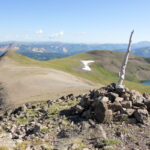
Hypothermia and the First glimpse of the Bighorn Flats
Shortly after rounding the turn on the seventh switchback, I got my first glimpse of the landscape I would be in for the next two hours. It looked like I was on a different planet, like a barren moonscape. Not only were there no trees or vegetation taller than grass, but also the only rock features of any note were stacked-rock cairns marking the trail. It was surreal and more than a bit intimidating. Coincidentally, I started feeling shaky. As the grade’s steepness lessened, so too did my exertion level. The physical work kept me warm in the 30 MPH wind and 45-degree chill. No longer. I realized hypothermia had hit me. I stopped briefly to put on another layer, but the damage had been done. The altitude was 12,000 feet. Colors were muted, and everything had an otherworldly look to it.


Start of Bighorn Flats looking back to where I had hiked – North Inlet Valley in upper right
Fighting off passing out and panic in Rocky Mountain NP


Wind howled as I started crossing the Bighorn Flats. It was steady at 35 MPH, and the temperature was still in the 40s. Despite putting on more layers, I felt chilled to the bone. Worse, I started feeling lightheaded and, frankly, scared. Emotionally, the constant sound of the wind was a total beat down. I didn’t feel well, and began to get nervous that my physical state would deteriorate to the point I couldn’t continue. And that was NO place to stop! It took all my confidence, experience, and wits to keep the building panic pushed down. Realizing I was dealing with hypothermia, dehydration, and low blood sugar, a cairn provided a break to deal with each. I wrote a website article telling this ‘story.’ You can read it here.

North Inlet Trail – Tonahutu Trail intersection near Flattop Mountain
Reaching the summit and starting downhill – the situation improves
In addition to a much-needed boost from a liter of water, electrolytes, and two Gu gel shots, three things happened almost simultaneously to improve my situation dramatically. As I approached the intersection with the Flattop Mountain Trail, I saw a group of hikers ahead. They were coming toward me. As they passed we had a short conversation. Simply knowing there were other humans up there with me was incredibly uplifting! Also, I came to Ptarmigan Point. The view was both unexpected and amazing. Finally, I hit the climb’s summit from the July CG and started down. The downhill was barely noticeable, but the thought I was heading back off that stark landscape boosted my spirits substantially. I was only halfway through the seven-mile Flats, but things were looking up.


View from Ptarmigan Point
Heading down – Approaching treeline and the Tonahutu Creek Valley


I still had four hiking miles to the end of the Bighorn Flats ‘danger zone,’ but I was making good time. Smooth trails and a gentle downhill grade enabled a four MPH pace. Each step was three feet closer to treeline, which I could tantalizingly view in the distance. Even the colors became more vibrant as the descent brought me into ‘thicker’ air. My mood improved with each step toward the trees. Distances get distorted in that wide-open terrain. Treeline appeared closed than it was. Progress was painfully slow. Soon the downhill grade steepened and I started running into hikers doing the CDT Loop in the clockwise direction. Just before I came to the treeline I reached a creek. It was the first water in seven miles.

Heading downhill on the Tonahutu Creek Trail with Tonahutu Creek Valley in distance
“There is no glory in climbing a mountain if all you want to do is to get to the top. It’s experiencing the climb itself – in all its moments of revelation, heartbreak, and fatigue – that has to be the goal.” – Karyn Kusama
Back into the trees in the Tonahutu Creek Valley
Coming upon water was welcomed and much-needed. Though the wind had calmed with the descent, it was still blowing at 20 MPH. There was a depression where the creek passed through, and it provided shelter from the breeze. The sun’s warmth felt heavenly. With a beautiful scene in front of me, warm for the first time in a while, rested, rehydrated, and fed, it was hard to imagine how badly I felt just an hour previously. It was now late morning, and there was no indication that the perfect weather would deteriorate. I knew I had been lucky. It had been a very long day already, and I still had over three miles to hike to get to my campsite at Granite Falls. After filling up with enough water for the rest of the hike and some more for camp, I packed up and started toward the trees.


Approaching treeline at the start of the Tonahutu Creek Valley
YouTube Video – Scary traverse across Bighorn Flats
Fast hike on the Tonahutu Creek Trail to Granite Falls – and a fall!


Not long after I made it back into the treeline, I came to the second ‘Mountains Don’t Care’ plaque. Even though it had only been seven miles on relatively easy trails, it felt like a significant accomplishment. Passing one campground after another – Timberline, Renegade, and Tonahutu Meadows – made me realize how less-than-ideal my permit had been. But even with ‘bad’ campsites on both sides, it had still been just a 13-mile day. Challenging but not torturous. I was anxious to get to Granite Falls and let my concentration fade. It cost me! I caught a root with my foot and fell hard. The microphone shock system was destroyed. Also, I found out later my left leg below the knee had a hard impact with a rock.

Approaching treeline at the start of the Tonahutu Creek Valley
Rocky Mountain NP Night #2 at Granite Falls Campground
Arriving at Granite Falls was great. It had been a long day! Between 13 hiking miles, 6000 vertical feet (3K up, 3K down), hypothermia, dehydration, low blood sugar, whacked electrolytes, altitude issues, and a nasty fall, I wasn’t feeling so good when I finally stopped for the day. On top of that, when I sat down in camp, I randomly rubbed my hands down my leg and felt a large bump that wasn’t supposed to be there. I pulled up my pants and found what looked like a second kneecap below the ‘official’ kneecap. Ouch. It freaked me out, primarily because I worried it would swell into my knee area and lock up my leg. I wrapped it tightly with a compression wrap and hoped for the best. It had been a great day, but it had taken its toll on me. And there were still eight miles to hike.


View of the meadow north of Granite Falls from my campsite – view in direction I hiked down from
YouTube Video – Descent to Granite Falls Campground
Rocky Mountain National Park CDT Loop Hike Day #3
Granite Falls to Big Meadows


I was concerned that my ‘2nd kneecap’ would cause a big problem when I awoke the last morning. But to my great relief, the swelling hadn’t extended into my knee, and the joint movement was fine. It hurt like heck, but I could walk. It was eight easy miles from Granite Falls to the trailhead. All downhill on good, smooth trails. The worst grade came immediately after leaving camp. A steep hill descended to the Lower Granite Falls campsite. Halfway down, I captured a flat, shadowy picture of the falls from a viewpoint. The hiking was pleasant – through woods and along Tonahutu Creek. Occasionally, the trail would pass through areas of dead pines – a victim of the Pine Beetles infesting large areas in the Rockies.

Granite Falls
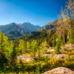
Big Meadows
After two forested miles, the trail began to show glimpses of a large open area ahead. It was Big Meadows, which stretched for two miles along the left side of the trail as it made a bending turn to the south. Big Meadows was breathtakingly gorgeous. Blanketed with yellow fall grasses, deep blue skies overhead, Tonahutu Creek flowing, and unobstructed views of green forested Mount Patterson and Nisa Mountain. The hike through Big Meadows was undoubtedly the highlight of my last day of hiking. Unlike the bone-chilling temperatures and howling wind from the Bighorn Flats, it was pleasantly warm with a gentle breeze. You couldn’t stop yourself from smiling at the pleasantness of the moment. I was eager to finish the hike but also never wanted that peaceful, perfect hiking to end.


Big Meadows with Tonahutu Creek Trail to the left – area I hiked down from in the distance
Passing final Rocky Mountain National Park backcountry campsites


I found myself in the area of Green Mountain campsite, which, according to my permit, is where I was to spend my third night. But my plan all along had been to hike directly from Granite Falls to the trailhead and forego a third night in the backcountry. At the southern end of Big Meadows, I was four miles from the car, a bit less than an hour of hiking. I passed my last Rocky Mountain National Park campsites – Big Meadows, South Meadows, Paint Brush, and Lodgepole. All were similar to every camp I’d stayed in and passed. I left convinced there are no ‘bad’ campsites in RMNP. I entered a pleasantly open pine forest, thankfully unaffected by pine beetles. The rest of the hike would be through similar peaceful pine forest.
The home stretch – Rocky Mountain NP hike ends
Civilization started to infringe upon the hike as it neared the end. A mile from the trailhead I passed two groups of day hikers from the Kawuneeche Visitor’s Center. That is where I had picked up my perfect a few days earlier. A few hundred meters later, I came to the intersection with the side trail to the Grand Lake Lodge. All the hiking towards the end was through healthy lodgepole pines. They were shaded enough to temper the wind and temperature but sufficiently open for views and the sun to penetrate. Trails were smooth, slightly downhill, and wide enough to be a road (to accommodate crowds of day hikers). It was some of the most pleasant hiking of the entire trip. Being less than a mile from the finish certainly augmented my already good mood.


Tonahutu Creek Trail as I approached the trailhead, and the end of the hike
YouTube Video – Big Meadows and final miles back to trailhead
Conclusion – Rocky Mountain National Park Backpacking
I arrived at the trailhead with a slight limp and a smile. Being a ‘flatlander,’ completing a Rocky Mountain hike always feels like an accomplishment. This one had been more of a test than most. Various hikes have defined themselves in specific ways. The 2018 Wind River Range hike set the ‘standard’ for clouds of mosquitoes. Similarly, the 2019 Big South Fork hike taught us about ticks. The 2015 Four Pass Loop and 2018 AT Triple Crown hike were known for endless rain. The 2016 Rocky Mountain NP CDT Loop hike is remembered for hypothermia and fear for my health. There have been colder moments – my cold night at Boulder Pass in Glacier – but never before or since have I experienced the deep-down, bone-chilling, terrifying, slow onset of hypothermia. And the potential panic it can induce. I lived… and learned. And it was indeed a bucket-list-worthy hike.

Author ‘selfie’ on Tonahutu Creek Trail near end of hike