South San Juan Wilderness Backpacking – August 2012
Platora, Colorado – August 2012
3
AUGUST, 2012
Our first Rocky Mountains backpacking ‘adventure’ was the 2011 Mount Zirkel Wilderness hike. That trip did not go well! Ignorance of typical seasonal snow depth levels combined with poor planning and logistics led to a complete change of plans from our original hike. Christian, Jaden, and I still had a great time – just not anything close to the trip we had planned going into it. But we learned a ton from the Mount Zirkel Wilderness experience, and all the lessons combined to make the 2012 South San Juan Wilderness trip our first successful Colorado hike.
Long Drive to Alamosa, Colorado
Where is Alamosa, Colorado?

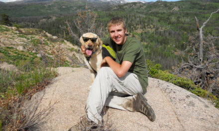
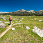
Excited and better prepared for our 2nd Colorado hike


Pre-trip preparations were like night and day from the 2011 Mount Zirkel Wilderness hike. Also, the trip was significantly more complex than in 2011. After the hike, we planned to go to Crested Butte, Colorado, to go mountain biking on the famous 401 trail. Backpacking, mountain biking, car camping, and hotels were all planned. But this time, we were ready. After the 2011 trip, I told myself, “I’ll never hike in Colorado again before late July.” This trip would end at the beginning of August. Snow depths were checked and confirmed to be ok. Gear for every different aspect of the trip was organized separately and confirmed using new checklists. We were as ready as we could be. The drive across the plains was long, but uneventful.

Stopping to take pictures at the Colorado border on US-40
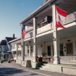
Arrival at the Lamplighter Inn in Alamosa, CO
Normally, on drives to Colorado, I leave in the afternoon and drive through the night. On this trip, we left early in the morning and drove 16 hours straight to Alamosa. I learned Alamosa isn’t a tourist haven jam-packed with lodging options. It’s located in southern Colorado, almost in New Mexico, and far away from Colorado’s popular tourist areas. Because of that, lodging options were limited, and dog-friendly options were virtually non-existent. The Lamplighter Inn was the only place I could find that allowed dogs. It received mixed reviews, but ‘clean’ was often used. We arrived after midnight and had to call a number on the window. But it served its purpose. I’ve learned that the Lamplighter has closed since our visit.


2012 South San Juan Wilderness Hike Plan
The 2011 Mount Zirkel Wilderness hike taught me much. Our pre-trip planning and logistics had been much improved as a result. Another thing we learned without actually having to experience it is the hiking miles we had planned in 2011 were excessive. Guides at the Vista Verde Ranch recommended keeping the hiking miles lower on future high-altitude western trips and allowing for time to acclimate to the altitude. To that end, the 2012 plan was to hike up to Blue Lake on the first day and spend two nights there. We could acclimate while exploring the surrounding area on the Continental Divide Trail. A two-day side excursion to climb Conejos Peak was also in the plan. It was a flexible plan that gave us many options based on how we felt and what we discovered during the hike. In total, we planned a 5-day, 4-night hike.

South San Juan Wilderness Hike Day #1
Rough drive to the Platora Reservoir Trailhead


The first mistake of the trip was the route I chose to get to the trailhead. Instead of the longer route with better roads on CO-17, I decided to take FR250 for roughly 30 miles to the trailhead. It seemed ‘reasonable’ on the map. What I hadn’t considered, and should have learned from our Forest Road experience on the Hahns Peak hike in 2011, was Forest Roads can be rough. Very rough! The FR250 drive was initially smooth and beautiful, but as we climbed up and over Stunner Pass, I realized a Saab 9-5 is no substitute for a 4-wheel-drive Jeep. But we made it through the worst of it at the Pass, and the roads smoothed out again. Based on the isolation of the drive, I was stunned to find the trailhead packed with vehicles.

Platora Reservoir Trailhead
YouTube Video – Drive to Platora Reservoir Trailhead
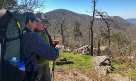
Trailhead to Three Forks


Despite all the cars at the trailhead, only a few day hikers were out as we started hiking south on the Conejos River Trail. The trail was ours alone just a mile south of the trailhead. It was a pleasant day for hiking. Temperatures were in the 70s, and humidity was low. Puffy clouds added to the scene, but I knew in late July in the Rockies, those clouds would build into afternoon storms. The trail was smooth with a gentle grade. As a result, our hiking pace was fast – about four MPH. We reached the first significant milestone, Three Forks, two miles into the hike. The Conejos River Trail split here into three different trails. One trail went up each of the three valleys that ascended to the Continental Divide Trail above.

Group picture at the start of the hike
Uphill on the El Rito Azul Trail to Blue Lake
At Three Forks, we turned left on the El Rito Azul Trail (translation is “The Blue Rite”). It ended at Blue Lake, our first (and second) night destination in the South San Juan Wilderness. From Three Forks (10,250 feet) to Blue Lake (11,500 feet), the El Rito Azul Trail ascended 1,250 feet over four miles. Shortly after Three Forks, the trail entered the woods, and we climbed in a pretty setting alongside a creek named El Rito Azul. The grade was not steep but continuously uphill with no flat sections. High altitude impacted us, but only to cause mild shortness of breath from the exertion. Neither Christian nor I felt any altitude sickness. It started to rain, so we stopped to don our rain gear. But almost as soon as it started, the rain stopped.


El Rito Azul Trail halfway to Blue Lake, with storms building
YouTube Video – Hike to Blue Lake
Campsite at Blue Lake


Halfway up the four-mile climb, we emerged from the woods into a valley of open fields with El Rito Azul at the bottom. The trail hugged the ridge on the west side a few hundred meters above the creek. Christian had enough energy to hike to the stream for pictures and climb back up. I said ‘no thanks’ to that use of energy. The climb steepened as we turned uphill back into the woods. Three Forks was the last time we saw other hikers. Just below Blue Lake, horses appeared uphill in the valley meadow. We had a fleeting thought that they were wild horses but noticed a cabin-style tent nearby. We had arrived at Blue Lake. As we passed, the occupants of the tent told us about a nice campsite near the shore of Blue Lake.

Camp at Blue Lake
“Ages of volcanic activity followed by the carving of glaciers left the imposing terrain of the South San Juan Wilderness. You’ll find 180 miles of trails, and some of the most exemplary backpacking in the state. The Continental Divide crosses the heart of the Wilderness. The Conejos Peak Trail climbs to the summit of Conejos Peak and offers a fantastic view into the heart of the area.” – Wilderness Connect
South San Juan Wilderness Hike Day #2
Stormy night but clear skies in the morning
All night in camp, it had rained lightly and had the look of more severe storms. Those storms rolled in about midnight while we were ‘safely’ tucked into our sleeping bags. It had been a while since I went through gnarly lightning storms at 11,500 feet. When the storms roll over you, you’re in the clouds where they originate. It’s ‘exciting.’ All you can do is hope (pray) that the next bolt of lightning isn’t meant for you! Fortunately, none were. The storms moved on, and it held the promise of a clear, beautiful day. Fog lingered over Blue Lake in the morning while Jaden and I explored around our camp. It felt great knowing we would camp another night at Blue Lake. Our plan was to do a day hike around camp on the CDT.


Camp at Blue Lake in the morning of day #2
Day hike on the Continental Divide Trail above Blue Lake
South on the Continental Divide Trail to source of El Rito Azul
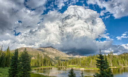
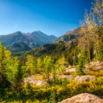
Knowing we didn’t have to pack up camp and move on, it was an enjoyable, lazy, and relaxing morning at Blue Lake. Our plan was loose – to do a day hike along the Continental Divide Trail south of Blue Lake. The Navajo Valley extended into that area from the southwest corner of Blue Lake. I wanted to explore that area because it is known as the last spot where Grizzly Bears existed in Colorado. The day was perfect. Warm enough for shorts and t-shirts with little chance of rain after yesterday’s storms moved on. The hike started on the CDT for a mile south from camp. Christian took off cross-country at that point, and Jaden and I followed. It was an above-tree-line area with magnificent views in all directions.


Exploring the Navajo Valley
We stopped for lunch at a pretty, unnamed tarn that appeared to be the source of the El Rito Azul. Continuing west after our break, we came to the impressive Navajo Valley. It was like a mini Grand Canyon, only a few miles from our Blue Lake camp. Christian wandered onto a sketchy rock cliff to get ‘better’ pictures (meaning, more death-defying!). It was a relaxing and pleasant hike. There was no hurry to go anywhere, and our pace was slow and easy. Our camp was already set up and only a few downhill miles away. We climbed one last rocky hill. Stretched out below us was a fantastic view of Blue Lake, the El Rito Azul Valley, and Conejos Peak in the distance.


Christian and Jaden on rocky hill overlooking Blue Lake and El Rito Azul – Conejos Peak in the distance
“A great bear was killed here (Navajo Valley, near Blue Lake) in 1979, the last known Colorado grizzly. But rumor, extrapolation, and scientific evidence all join hands to suggest strongly that more grizzlies, if they still live anywhere in Colorado, inhabit the recesses of this rugged Wilderness, which many claim as the wildest left in the state.” – Wilderness Connect
YouTube Video – Day hike on the Continental Divide Trail
Second night in the South San Juan Wilderness at Blue Lake


It was mid-afternoon when we returned to camp from our day hike. There was plenty of daylight left to enjoy our second night at Blue Lake. While I gathered wood and worked on getting a campfire going, Christian prepared the fishing gear. He hoped to catch some fresh trout for dinner. I had learned with my pre-trip research that the fish in Blue Lake were ‘smart.’ Many hikers trying their hand at fishing had come up empty. Others had great results. It came down to the proper choice of tackle. Christian cast his rod for a couple hours. Despite his best efforts, dinner was destined to be Mountain House, not trout. He still had a great time fishing in a beautiful setting. It had been a great day in the South San Juan Wilderness.
South San Juan Wilderness Hike Day #3
Two-day side excursion to climb Conejos Peak – hike to Twin Lakes
We had always planned to hike to the summit of Conejos Peak. It could have been done as a VERY long day hike from Blue Lake. That would have been about 18 miles round trip. Not only would that have been brutal, but it would also have been dangerous. Reliable lightning storms were building up each afternoon, and a day hike that long would have put us on the summit of 13,176-foot Conejos Peak at peak lightning time. A better plan, our plan, was to hike to Twin Lakes near the base of Conejos Peak today, summit early tomorrow, and then hike back to Blue Lake. The day was again perfect. We followed the CDT south from Blue Lake but turned north and uphill. Elevation was near 12,000 feet, and it was entirely exposed. Our lunch break was at gorgeous Glacier Lake.


Group shot during lunch on our hike to Twin Lakes, with Glacier Lake in background
Camp at Twin Lakes


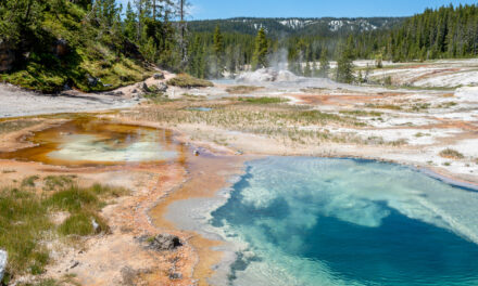
Just after lunch at Glacier Lake, we descended a steep ridge towards a bowl-like area where Twin Lakes was located. Between the 80-degree temperatures, bone-dry humidity, 100% sun exposure, and 12,000-foot altitude, we were baked. Fortunately, we found a nice camp spot with some tree cover. There wasn’t much shade, so I set up the tarp to give us a decent place to sit. Christian crawled into the tent to nap while Jaden and I explored. There was little to explore! I replenished our water from the lake. It had a strong mildewy odor and flavor. Not exactly enjoyable to rehydrate with, but we needed it badly. A bit of firewood was scraped together to build a small fire. We planned to get up early and start the climb up Conejos Peak.

Camp at Twin Lakes
YouTube Video – Hike from Blue Lake to Twin Lakes
South San Juan Wilderness Hike Day #4
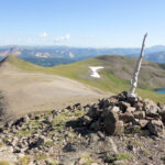
Climbing Conejos Peak
Another cloudless day greeted us when we started the hike up Conejos Peak at 7 AM. As soon as we left camp, we had a brutal climb. But once we reached the top of the bluff, the trail leveled out, and our pace accelerated. At a tarn near Conejos’s base, we ran into a large herd of Elk. It rejuvenated us for the climb. The trail was nearly impossible to follow. Ultimately we decided to abandon the trail and go straight up the side of Conejos. Not a good decision! The climb was extremely steep on loose scree. Progress was slow and tortuous. We often stopped to suck in air. The altitude was nearing 13,000 feet. Eventually, we reached the summit. Knowing time was critical, we took pictures and briefly soaked in the view. Heading down was fast, and all too soon we were back in our camp.


Summit of Conejos Peak
YouTube Video – Climbing Conejos Peak
Back at Blue Lake camp – last night in South San Juan Wilderness


As I had planned, we returned to our Twin Lakes camp a few minutes before noon. It had already been quite an eventful morning! We had hiked seven miles with 3000 vertical feet of elevation change and summited Conejos Peak. We still had seven more miles to hike back to Blue Lake. Fortunately, aside from the nasty climb just south of Twin Lakes, it was all downhill. As we rested on the climb, I saw thunderstorms on Conejos – our timing and plan had been spot on. The hike back to Blue Lake was fast and uneventful. Despite 15 miles of hiking with a ton of terrain, we all felt terrific. Perhaps even a little proud of what we had done. Christian found unique shelter under the tarp – the storms had followed us to camp.

Jaden chilling out in Blue Lake after our long Conejos Peak day
South San Juan Wilderness Hike Day #5
It was a great last night in the South San Juan Wilderness. Rain fell throughout the night, but we stayed dry under the tarp. A fire near the entrance provided warmth. It was a pleasant way to end our trip. Christian and I discussed all we had done over the last four days and made plans for our first Glacier trip in 2013. After packing up camp for the last time, we started the downhill hike to the trailhead. Not far from Blue Lake, we discovered fresh bear tracks on the trail. For the remainder of the hike, we kept our eyes peeled for Ursus americanus but saw no further sign. With our 4+ MPH pace, we were soon back at Three Forks. Many day hikers started to appear on the trail. It was yet another perfect Rocky Mountain day. Soon we were back at the trailhead and the car.


Downhill on the El Rito Azul Trail on day #5 in the South San Juan Wilderness
Conclusion – South San Juan Wilderness Backpacking, Aug 2012
We had come a long way since our July 2011 experience in the Mount Zirkel Wilderness. Reflecting on it, I realize the painful lessons we learned in 2011 directly contributed to the success of our 2012 South San Juan Wilderness hike. The pre-trip planning had been thorough, and, as a result, we were prepared for everything we ran into on the hike. Every backpacking trip is a ‘learning experience,’ but between the 2011 and 2012 Colorado hikes, I gained an entire encyclopedia of trail knowledge. Since those first Colorado hikes, I have made dozens of backpacking trips to all of the iconic destinations out west – Glacier, Yellowstone, the Sierra Nevada, Wind River Range, and many more Colorado trips – and the success of all those hikes is a tribute to that first truly successful Colorado trip – the 2012 South San Juan Wilderness.

Group shot on the summit of Conejos Peak