AT Grayson Highlands Backpacking – April 2017
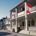
Damascus, Virginia – April 2017
29
APRIL, 2017
Prior to my first Appalachian Trail hike in 2016, I created a list of potential AT destinations. The Roan Highlands in northern Tennessee topped that list. It’s the reason I chose that area for my first hike. But the second slot on my AT ‘dream hike’ list went to the Grayson Highlands in southern Virginia. I fell in love with backpacking on the Appalachian Trail during my 2016 Roan hike. Less than a year later, I would return to the AT, this time with Bob as my hiking partner. Together we would take on the Grayson Highlands.

Famous Grayson Highland wild ponies near Thomas Knob Shelter
“I’ve hiked the Appalachian Trail from Georgia to New Jersey, and Grayson Highlands may be my favorite section. It is so beautiful. Epic views, wild ponies, and rock formations – this place is incredible.“ – Tim R.
YouTube Video – 3-minute Trailer of Grayson Highlands AT hike
Where is Damascus, Virginia?

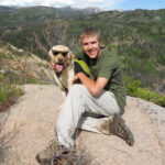
Doing the 2017 Grayson Highlands hike with Bob
Deciding to hike in the Grayson Highlands
Backpacking on the Appalachian Trail is ideal for solo trips. It is, above all, a social trail. A migrating community of sorts. My first hike in the Roan Highlands convinced me that you’re never truly alone when hiking the AT, even as a ‘solo’ hiker. There are hikers everywhere along the trail, and the shelters are like a magnet for people at the end of each day. After my great experience on the Roan hike, I was eager to get back to the Appalachian Trail in the spring of 2017. Initially, I had another solo hike in mind. But that all changed when I started talking to Bob about the hike.
History with Bob
Bob and I had done the July 2015 Four Pass Loop hike together. I credit Bob with much of my early knowledge of backpacking. When I first started backpacking, I had long conversations with Bob, a manager on my staff at Delphi in Kokomo, Indiana. We would talk about all things backcountry camping and gear. Bob was a veteran of many Boundary Waters trips. I ‘picked his brain’ for tidbits of knowledge and wisdom every chance I could. Bob even had a massive map of the Boundary Waters on his office wall. He would explain his previous canoe trips as we examined the map. I loved every minute of it and took his words of wisdom and tales of backcountry adventure to heart. I asked Bob if he was interested in joining me, and he jumped at the opportunity for an AT hike.
Traveling from Indiana to Damascus
Getting the drive started


Excitement was off the charts high when we started the drive. The springtime weather was perfect, and it felt great to be backpacking with Bob again. I was a little concerned when everything was packed in the trunk. It was jammed with ‘stuff.’ I knew most of that would be on our backs for the next four days! Fortunately, much of it was ‘day gear’ that would stay in the trunk. Bob is an easy guy to go on a trip with. Between work, our Four Pass Loop hike, his recent renewed interest in backpacking, the Boundary Waters, and all things gear, there was no end of topics to occupy the drive. Near Lexington, Kentucky, I realized our route would take us by legendary Miguel’s Pizza. We phoned in a take-out order!
An unplanned stop at Miguel’s Pizza
Pizza vortex. That’s what pulls you towards the famous Miguel’s Pizza anytime you’re in the area. If you’re ever anywhere near the tiny town of Slade, Kentucky, go there. Trust me! I first learned about and visited Miguel’s during my 2012 Red River Gorge hike. Every trip report I read said something like “…and of course, we made the mandatory trip to Miguel’s.” I did a little digging and found Miguel’s Pizza is a must-see destination that happens to also make great pizza. It’s where I learned that chorizo is fantastic on pizza. Their ordering peculiarities are legendary and fodder for one of my website ‘stories’ at some point (read it here). The pizza was fresh out of the oven and nuclear hot. Bob warned me, but I couldn’t wait!


Ham, Bacon, Pepperoni, and Chorizo pizza from Miguel’s Pizza
“Buy my pizza or I’m going to have to eat my goats” – Miguel Ventura
YouTube Video – Miguel’s Pizza
On to the Quality Inn in Abingdon, Virginia


No interstate highway driving is involved from Slade, Kentucky, to Abingdon, Virginia. Kentucky 15 to US-119, US-23, and finally US-Alt 58. Back road driving through the hills and mountains of Kentucky and then Virginia. It was nice! There was little traffic, and the weather was great. Mindless interstate driving is efficient and has its place, but sometimes it’s nice to mix it up. It was bedtime when we arrived at the Quality Inn, but Bob had some last-minute gear prep to take care of. It spiraled into some full-blown ‘pack anxiety!’ We walked over to the adjacent Huddle House in the morning for our ‘last meal’ before backpacking. Bacon, eggs, hash browns, and toast are always fantastic before a hike.

Group picture at Huddle House in Abingdon, Virginia – first morning of Appalachian Trail hiking
YouTube Video – Hike prep at Quality Inn and Huddle House breakfast
Appalachian Trail Roan Highlands Hike Plan
We planned a 4-day, 50-mile southbound hike starting at Dickey Gap and ending in Damascus. After we arrived in Damascus, the Mt Rogers Outfitters would give us a shuttle ride up to Dickey Gap, where we would start. The first day would be 10 miles, generally uphill to the Old Orchard Shelter. Our destination on the second day would be the Thomas Knob Shelter, another 10-mile day. The plan for day three would be 13 miles from the Thomas Knob Shelter to Lost Mountain Shelter. Unfortunately, that would still leave 16 miles for our final day into Damascus. We entered the hike with a vague notion of somehow altering the plan to make that last day a bit less brutal, but we would leave the details for the trail.

Day #1 – Appalachian Trail Grayson Highlands hike
Short early morning drive to Damascus
Gorgeous weather greeted us on our first morning of AT hiking. With full tummies from our Huddle House indulgence, we hit the road for the 20-mile drive to Damascus. Skies were clear, with some ground fog hugging the low areas as we cruised down US-58. Any hike in the Grayson Highlands area will naturally draw you to Damascus, sitting at the southern end of the section. Damascus’s marketing slogan is ‘Trail Town USA,’ also known as ‘The Friendliest Town on The Trail.’ The Trail Town slogan is well-deserved – numerous trails intersect and go through the town. We learned upon arrival that the ‘friendliest’ moniker was being questioned. Perhaps Damascus had grown weary of ‘hiker trash’ after so many years.


Mt Rogers Outfitters – Damascus, Virginia


Our first and only stop in Damascus would be the acclaimed Mt Rogers Outfitters, located in the center of town on the main drag. On any list of ‘most famous outfitters on the AT,’ it would rank at or near the top. In a town famous as ‘Trail Town USA, ‘ Mt Rogers Outfitters is the nerve center. And, as we quickly learned, it isn’t just hikers that are drawn there now. The Virginia Creeper Trail is an abandoned railroad line converted into a gently graded, paved bike path. Bike rentals and shuttles uphill to the start of the Creeper Trail are available. Riders effectively coast 25 miles back to Damascus. It’s fun and trendy! For us, the Outfitter would provide safe car parking during our trip and a shuttle north to Dickey Gap for the start of the hike.

Bob in front of Mt Rogers Outfitters – Damascus, Virginia
“Mt Rogers Outfitters is a great place. Huge Thru-hiker style inventory. Customer service through the roof! They try to play like they’re hardened ZZ Top backwoods crazy folk, but they’re really a bunch of softies. I mean that as a complement!” – Doug W. Review
Shuttle to Dickey Gap – Start of Appalachian Trail hike
Our shuttle driver arrived on time. We piled into an old Chevy Express van that had seen its share of hikers. Foam padding protruded from numerous tears on the driver’s seat. Valuable trail wisdom was shared throughout the 45-minute drive to Dickey Gap. Our driver also told us about increasing tension in Damascus directed towards hikers due to various ‘mischief’ attributed to thru-hikers. We passed an Appalachian Trail re-route north of town, where a washed-out bridge had never been replaced due to government regulations. I didn’t pay much attention then, but it would have more meaning later. The weather was perfect for hiking. Our excitement peaked as we turned onto the side road at Dickey Gap and the AT crossing.


Group picture at Dickey Gap – Start of the 2017 Appalachian Trail hike
YouTube Video – Start of the 2017 Appalachian Trail Hike
Up the hill to the Hurricane Shelter
Within minutes of our shuttle rolling to a stop, we were backpacking on the incomparable Appalachian Trail. ‘Special’ isn’t sufficient to describe how it felt hiking on the famous trail again. Bob turned trail ‘fan girl’ on me and snapped pictures like a teenager at her first Justin Bieber concert. (I’m glad because I used many of them in this article!). The weather couldn’t have been better – sunshine, low humidity, and temperature in the upper 60s. Vibrant green spring growth was emerging everywhere, and you could almost feel the forest returning to life after the long winter. Our first landmark was Comers Creek, flowing hard from recent rains. We met our first thru-hikers there and chatted for a bit. Soon the trail turned left and steeply uphill on Hurricane Mountain. After four miles, we came to the side trail to Hurricane Shelter. There, we took a break for lunch.


Lunch break at the Hurricane Shelter


Hurricane Shelter is located on a fairly steep hillside a mile from the summit of Hurricane Mountain. Conveniently, it was also the halfway mark of our hiking for day #1 and the first water source we had come to. It was the perfect place to stop for lunch. Our initial giddiness had long since passed. Steep climbs have a way of making it ‘real’ very quickly! I ‘took one for the team’ and climbed up the uphill blue-blaze trail to the shelter. Hurricane Shelter looked brand new. It still had a fresh-cut wood smell lingering. The slope it was located on was too steep to allow tenting. That caused us concern because we planned to set up tents at the Old Orchard Shelter six more miles down the trail. We would deal with that when we got there.

Sign marking blue-blaze trail to Hurricane Shelter
Final six miles on day #1 to Old Orchard Shelter
Climbing resumed after lunch. In total, it was 1200 vertical feet from Dickey Gap to the summit of Hurricane Mountain. Our early season legs weren’t used to the relentless, steep grade. In addition, the temperature had climbed into the mid-70s. But the early spring hiking in the woods was pleasant and made the effort and pain worth it. A family of deer enjoyed the woods along with us in one nice spot. We passed within feet before noticing they were there. After the summit, it was 1000 vertical feet downhill over just two miles to the SR-603 crossing. It had been a long day but a great one too. There was only one more climb to Old Orchard Shelter. Fortunately, the grade was gentler, and we soon saw the shelter off to our right.


Appalachian Trail-Old Orchard Trail intersection – one mile from Old Orchard Shelter
Old Orchard Shelter – first night camp in the Grayson Highlands


All afternoon our discussion had been about tenting at Old Orchard Shelter. Could we or couldn’t we? The steep slopes at Hurricane Shelter made us worried the same thing would greet us at Old Orchard. We shouldn’t have worried. Unlike Hurricane, Old Orchand was like a compound, spread out over a large area around the shelter building. Flat, grass-covered ground was nearby, sufficient to support many tents. It was a lovely spot, and a feeling of relaxed peace came over us. After setting up our tents, Bob got a fire going. The thru-hikers enjoyed that – they don’t typically expend the energy required for a fire. We had dinner and talked around the fire until ‘hiker midnight’ (dark). It had been a great first day on the Appalachian Trail.

Old Orchard Shelter with the tenting area in the background
Day #2 – Appalachian Trail Grayson Highlands hike
Morning rituals at the Old Orchard Shelter
Morning chores start early when you’re camping with a bunch of thru-hikers. Sounds of tents being broken down started well before 6 AM. Clear skies overnight led to chilly temperatures in the morning, and I was in no hurry to emerge from my Zpacks shelter. But Bob was up, and I wasn’t about to be the one who delayed our departure. I went up the hill to the privy to take care of my morning ‘business.’ The privy was a thing of ‘beauty.’ It had been built to full ADA compliance, with a wheelchair ramp and railings. That was a head-scratcher because anyone restricted to a wheelchair would have one heck of a time getting there or moving about. It harkened back to the shuttle driver saying the bridge had not been rebuilt.


Steep climb to start day #2 – closing in on wild ponies
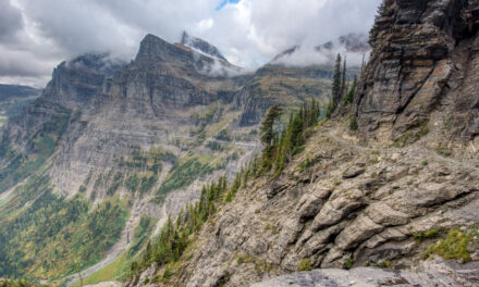
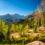
Our second day would be another ten-miles, ending at the Thomas Knob Shelter, 1500 vertical feet higher than Old Orchard Shelter. It would give us our first chance to see the famous wild ponies of Grayson Highlands. At three miles, we would enter Grayson Highlands State Park. Our day started with a steep climb on a rough trail through dark, hobbity woods as soon as we left the shelter area. The guidebook indicated the climb was 800 vertical feet over two miles – steep but not brutally so. It ended up being 1000 vertical feet in less than two miles over primarily slippery rocks and mud. Not a fun way to start a long day. Clear skies had surrendered to overcast, gloomy clouds, foreshadowing stormy weather. Once we reached the summit, at two miles, more open and exposed terrain would be with us the rest of the day.


Scales
Scales trailhead and campsite are like a hub of a wheel, with the spokes being four separate trails that intersect there. You come to it two miles after the summit of the climb from Old Orchard Shelter. A large, fenced grass field with a privy building, wastebasket, and a half dozen fire rings. Camping is allowed within the fenced area. Fences are generally intended to keep livestock in. These fences are meant to keep them out! Scales is located in an open-range grazing area and amidst Grayson’s wild ponies. It got its name from old cattle grazing days. Ranchers would weigh their cattle at Scales. The only water source is a spring, but it is not reliable. Scales is a popular AT landmark. We took a short break and pressed on.


The Scales – campground and trailhead
First exposure to wild ponies and above treeline, open spaces


Stone Mountain South Peak was the next ‘milestone’ after departing Scales. It wasn’t much of a peak or a milestone. But it gave us a taste of the ‘above treeline’ hiking we would enjoy the rest of the day. Wild ponies shared the trail with us for the first time, albeit from a distance. We would get much closer opportunities for pony interactions later. Treeless, open views afforded ample opportunity to see the mountains in the distance that stood in wait for us to arrive. Trails are everywhere in this area, and getting yourself ‘off trail’ (a.k.a. lost) wouldn’t be difficult if you get distracted. A mile after leaving Scales, we reached the ‘summit’ of Stone Mountain South Peak and gradually descended toward Wilson Creek.

Bob hiking away from Stone Mountain South Peak toward Wilson Creek
Wilson Creek bottomland area to Wise Shelter
Our time above treeline was just an appetizer for more open hiking to come. Less than an hour after leaving Scales, we returned to the Rhododendrons. A well-placed bridge gave us dry passage over one of the crossings of Wilsons Creek and its tributaries. But there were no bridges in multiple wetland areas where the trail had become a stream. Deep mud and thick tree cover made detouring around the submerged sections difficult. Our best option was to use stones as dry-land steps to make a way across like a puzzle. The swampy stuff only lasted about a quarter mile. We came out onto a grassy field, and on the far side was the Grayson Highlands State Park boundary. Wise Shelter was 100 meters inside the State Park.


“The Appalachian Trail has become a stream!” – Wilson Creek Bottomland
Wise Shelter – Boundary of Grayson Highlands State Park


AT Guidebooks will tell you, repeatedly, that tenting is not allowed at the Wise Shelter. The reason is the shelter is inside Grayson Highlands State Park. That is true. They don’t tell you that primo flat, grass-covered tenting space is located just 100 meters from the shelter, outside of the State Park boundary. Wise Shelter is located in a low area just past the Wilson Creek bottomland area. Regardless of which direction you hike from the shelter, it’s a healthy climb out. Multiple thru-hikers were having lunch when we stopped at Wise for a break. We joined them. Leaving the shelter, it was a steep climb back up to Wilburn Ridge. Thomas Knob Shelter was four more miles, which would be some of the best miles of the hike.
YouTube Video – Scales to Wise Shelter
Wilburn Ridge
Hikers at the Wise Shelter provided up-to-the-minute information on approaching severe storms. Our pre-trip weather research showed that storms were forecast to hit the area this afternoon. But the hikers told us we would be racing the storms to Thomas Knob Shelter. Increasingly gloomy and lowering clouds confirmed it wasn’t an idle threat. As we tackled the steep climb up to Wilburn Ridge, the clouds seemed to be coming lower at the same pace we were going higher. The warm temperatures we had enjoyed the entire hike were in the past. By the time we hit the climb’s summit, the temperatures were in the low 50s, and the wind had picked up to 25 MPH. It was cold! We both put on wind jackets and hiked on.


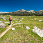
Grayson Highland Wild Ponies


If you’ve heard about the Grayson Highlands you most assuredly have heard about the wild ponies that make the area their home. In fact, the two are inseparable. The Grayson Highlands Wild Ponies aren’t some freak random occurrence of nature. They were introduced to the area after it was made Grayson Highlands State Park in 1965. Prior to that time, cattle grazed in the area maintaining the clear-cut appearance of the balds. When it became a State Park the cattle were removed and keeping brush in check became a problem. The ponies were introduced and thrive in the scrubby, mountainous terrain. Once a year the ponies are rounded up, medically checked, and excess ponies are auctioned off.

Wild Ponies of Grayson Highlands
Hiking in the Clouds
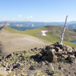
From Wilburn Ridge to the Thomas Knob Shelter is the most scenic area of the entire Grayson Highlands section of the Appalachian Trail. Not for us! Clouds that had been getting lower all afternoon finally swallowed us on the Pine Mountain ridge. Not only were all the awesome views obscured by clouds, but it was also cold, wet, and windy. At times it was so foggy that we couldn’t see the next white blaze. It made me appreciate the views that we did have earlier in the day, and on the first two days of our hike. Fortunately, the rain had held off thus far but we knew it wasn’t far away. Our pace quickened as we got within a couple miles of Thomas Knob Shelter.


YouTube Video – Hiking in the Clouds
Fatman Squeeze
Fatman Squeeze is a significant milestone on the Grayson Highlands section of the Appalachian Trail. All of the thru-hiker books I had read mentioned it, AWOL’s (David Miller) Appalachian Trail Guide listed it, and ‘Fatman Squeeze’ came up frequently in my pre-trip research. It is essentially a tunnel through a rock face. It is aptly named since the greater your girth the tougher it is to make your way through. The off-camber angles of the pathway through doesn’t make it any easier. Once we successfully emerged on the other side of the Squeeze, it was less than two miles to Thomas Knob Shelter. Mist that had been constant since the clouds rolled in started to get a little ‘thicker.’ We knew the heavy rain was close. Soon we started seeing tents set up amongst stunted pine trees. We had arrived at the Shelter.


YouTube Video – Fatman Squeeze

‘500’ AT miles written in horse dung near Thomas Knob Shelter
Thomas Knob Shelter – Grayson Highlands night #2
Thomas Knob Shelter is a two-story shelter with room for 16 hikers. That’s a BIG shelter by Appalachian Trail standards. The first level is typical but larger than usual. It’s open in the front, relatively nice, and bright on the lower level. The second level is far less ‘nice’ – dark and cramped, with a low-sloped roof. You REALLY don’t want to stay on the second level. We were on the second level! But we had no choice if we were going to stay in the shelter. Our first choice was to set up a tent, but tent sites around Thomas Knob shelter are limited. We walked around looking for a spot, but they were all full. With gnarly weather moving in, both levels of the shelter were packed. In the end, we squeezed 18 hikers into the 16-hiker shelter.


Thomas Knob Shelter
A few more memories from my night at Thomas Knob Shelter
The picture above of the shelter’s upper level doesn’t do it justice. The picture is MUCH brighter than reality. Each end had a small window (~10″X16″). They were the only source of light. It was also dark and gloomy outside. As a result, even during daylight, there was barely any light illuminating the ‘attic.’ Access from the first level was through a 16″ square cutout on the wooden floor. You climbed a narrow, backward-slanting ladder to get to it. Oh, and mice… lots and lots of mice. AT Shelters are famous for mice, and Thomas Knob is known as one of the worst mice-infested shelters. I did ‘battle’ with one persistent mouse all night as I was trying to sleep. The upper level was not pleasant. In the middle of the night, I had to get up to go outside to the bathroom. I’ll leave that experience to your imagination!
YouTube Video – Thomas Knob Shelter upper-level
Day #3 – Appalachian Trail Grayson Highlands hike
Gorgeous morning in the Grayson Highlands at Thomas Knob


Storms continued through the early morning, but the skies were clear by sunrise. We emerged from the shelter to a spectacular morning. Visibility was unlimited, giving us the views we had missed yesterday. It was worth the wait! Valleys far below were filled with clouds making it seem we were on top of the world. Thru-hikers emerged and quickly packed up, ate breakfast, and started hiking. By that time in their hike (500 miles), their morning chores were efficient. Our first two days of hiking in the Grayson Highlands had been slightly over ten miles each. Those would be our two shortest days by far. Bob and I still had 30 trail miles to get to Damascus and two days to do it. With that in mind, we got going on our morning chores.

Morning view from water source trail behind Thomas Knob Shelter
Wild ponies at the Thomas Knob Shelter
Thus far in our hike, Bob and I had been a little disappointed with the lack of close encounters with the wild ponies of Grayson Highlands. We had seen our fair share, but mainly at a distance. That all changed in the morning at Thomas Knob Shelter. One curious pony came right up to the shelter’s front opening. Hikers took turns getting a free leg-washing from the pony. I called it a ‘mutually beneficial’ arrangement. The pony got some much-needed salt, and the hikers got a morning ‘bath.’ The pony had zero fear of humans – it clearly wasn’t his first such ‘rodeo,’ so to speak. A group of other ponies hung out in a field nearby but never found the courage to come to the shelter. We would have our time with them soon.


Enjoying the ponies from a warm sleeping bag at Thomas Knob Shelter
Getting the 3rd day of Appalachian Trail hiking started – More ponies


Our plan for day #3 on the AT was fifteen or so trail miles. But the pace was slow to start the day. A hundred meters from camp, a group of ponies blocked the trail. Working around them would have been simple, but we decided to take advantage of the ‘photo op.’ Salt seems to be a priority for all the ponies, and one of them decided to do some salt-licking on my sweat-encrusted front fanny pack. I was filming and couldn’t tell where the pony was ‘aiming’ his tongue. The fanny pack was a bit too close for ‘comfort’ to more sensitive body parts, so I tried to ‘shoo’ the pony away. He was having none of it. Ultimately, a little pony head shove was necessary. But I was able to capture a very close-up shot of a Grayson Highlands pony.

Up close and personal with a Grayson Highlands wild pony
YouTube Video – Ponies at Thomas Knob
Deciding to change clothes and discovering a missing shirt
There had been a chill in the air while we were getting ready at the shelter, but it didn’t take long to realize it was going to be a warm day. My long sleeve Smartwool base layer was already too warm when we reached the Mount Rogers Summit blue-blaze trail at 1/4 mile. Unfortunately, when I dug into my pack for my short sleeve shirt it was not there. I assumed I had left it in the dark upper level of the shelter, so I headed back. It wasn’t there either. After a rather healthy ‘pack explosion’ failed to find it, I decided to dig down into my sleeping pack. Eureka! It was there. We had only made 1/4 mile of progress but I had already hiked over a mile, and the day was an hour gone.


Gradual descent from Thomas Knob


Shortly after the Mount Rogers Summit trail, we gradually descended off Thomas Knob. It was a perfect day for hiking. There wasn’t a cloud in the sky, visibility was unlimited, the humidity was low, the wind was calm, and the temperature was in the upper 60s. If someone were to ask you, “what are your perfect conditions to hike in?” the answer would have been “this.” That day made up for the foggy, cold conditions and lack of views the previous day. Maintaining our bearings was easy. Whitetop Mountain loomed in the background, and our route would go around the summit. Bob and I took a leisurely break in a pretty grove of leafless trees. It was going to be a very long day, and we were off to a slow start. But we were happy.
Elk Garden Ridge
Elk Garden Ridge sits at the base of Mount Rogers. It’s a classic bald area resembling a huge grass-covered athletic field. Dandelions were everywhere, lending a yellow hue to the green grass. With cloudless azure blue skies above, the scene resembled a vibrant nature painting. Combined with the sun’s warmth, I was tempted to lie down and nap. But we were way behind schedule, so stopping wasn’t an option. If we didn’t do something to pick up our pace, it would be a 20+ mile day tomorrow. Optimistically named, Balsam Mountain was more of a high spot, but it offered a great view of Elk Garden below and Whitetop Mountain beyond. We took advantage of the bathroom and wastebasket at Elk Garden for a short break.


Elk Garden and Whitetop Mountain as seen from Balsam Mountain – SR600 in saddle between
YouTube Video – Elk Garden
Climbing around Whitetop Mountain to Buzzard Rock


After our break at Elk Garden, the climb up and around Whitetop Mountain began. It was two miles and 800 vertical feet to the top of the climb. The day had become quite warm, and all our hiking thus far had been generally exposed on treeless balds. Thankfully, the climb up Whitetop started in a pine forest. Evergreens were the only trees that could give us much shade, and the temperature amongst the pines was noticeably cooler. But once we reached the top of the climb and crossed the road to Whitetop’s summit, the trail was treeless once again. Incredible views continued, though, and we could see Buzzard Rock in the distance. After Buzzard Rock, we would begin a steep 2000 vertical foot descent over 2.5 miles to SR601.
Lunch break at Buzzard Rock
Whitetop Mountain is Virginia’s second highest peak at 5525 feet. Buzzard Rock is listed amongst the top five highest ‘peaks’ in Virginia as well (5107 feet) though it is just a spur of Whitetop. Regardless, the entire area rises well above the surrounding countryside, and the views in all directions are fabulous. The wind had begun to pick up, and there was nothing to temper it, so we decided to take advantage of the tiny amount of shelter Buzzard Rock provided and have lunch. We nestled amongst the rocks which gave us protection from the wind. The rhyolite outcropping also provided seats to give our legs a gravity break. We had hiked seven miles thus far and had about seven more to go. We didn’t yet know where we would stop.


2000-foot descent to SR-601


The descent from Buzzard Rock is the steepest and longest grade of the entire Grayson Highlands section. It is consistent at nearly 1000 vertical feet per mile. Halfway down the descent, we met a group coming up that was suffering with heavy packs. They asked us if the climb was almost finished (it wasn’t… not even close). We gave them the most encouraging words we could and felt thankful we were heading down, not up. Balds gave way to forest hiking after we dropped from the saddle between Beech Mountain and Buzzard Rock. There would be no more open, bald hiking for the remainder of the hike into Damascus. A half mile from SR-601, the grade started to lessen as we hiked through a shady pine forest.

Start of 2000-foot descent from Buzzard Rock to SR601 – Beech Mountain in upper right
SR-601 to US-58, then uphill to the Lost Mountain Shelter
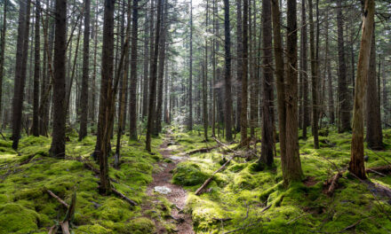
Transitioning from the relative darkness of the forest to the open sunshine at the SR-601 crossing was sudden. Across the road were a tranquil open field and a stile to keep cattle in while letting hikers through. An ‘Appalachian Trail’ directional sign pointed to where the trail resumed. From that point to the Lost Mountain Shelter was 1.5 miles. Our original plan had been to stay at the shelter for the night, and we were leaving that possibility open, depending on what we found when we arrived. But if we camped at the shelter, we would have 18 miles to hike on the last day – not a ‘fun’ way to end it. So we thought to rest at the shelter for a bit, tank up on water, and then hike on for another hour or so. After crossing US-58, we hiked one mile uphill through rhododendrons to the shelter.


Lost Mountain Shelter
Lost Mountain Shelter is a standard, log-constructed AT shelter. It’s on the large side, sleeping eight comfortably. The area around the shelter was a pleasant, open forest with tall, skinny leafless trees. Open ground with no forest undergrowth extended for 100 meters away from the opening of the shelter. A picnic table and a fire ring were in front of the shelter. It was a lovely spot. Bob and I were pretty spent when we arrived, and it was tempting to end our day there. But we both wanted to press on further. We filled up on water at a stream behind the shelter and down a small hill. Resting for 30 minutes revived us remarkably well. After our short rest and snack break, we said goodbye to the thru-hikers at the shelter and hiked on.


Guthook App stealth camp in the rhododendrons


Early in the hike, a thru-hiker called ‘I Don’t Know’ told us about the Guthook app, now called FarOut. If you’ve never heard of or used it, I recommend you check it out. It’s incredible! Guthook indicated a ‘stealth’ campsite in an opening in a rhododendron thicket two miles beyond Lost Mountain Shelter. Precisely at the spot indicated, we found a small side trail going off the AT. We checked it out and found the coolest small open space completely hidden from the main trail. It was small but big enough for Bob and me. There was a stream right next to it where we could get water. Bob set up his hammock and relaxed as we reminisced about our long day. After a late-night dinner and enjoying a small fire, we crawled into our tents.

Group picture in Rhododendron Camp on night #3
YouTube Video – Rhododendron Camp
Day #4 – Appalachian Trail Grayson Highlands hike
Leukotape Morning in Rhododendron Camp


You may have never heard of Leukotape, but I’m guessing you have if you’re a hiker. And if you’re a hiker and don’t know about Leukotape… well, time to do some googlin’. Leukotape is described as ‘high strength rigid tape with a very strong zinc oxide adhesive.’ Basically, it sticks to skin REALLY well. Hikers use it effectively as a new or additional layer of skin when blisters form. It can be a lifesaver (probably not literally, but you might feel that way). I always carry Leukotape on hikes. Our 35 trail miles thus far had torn up Bob’s feet. We applied all the Leukotape I had to help him through day #4. Ultimately, it would help, but it wouldn’t be enough. Bob was suffering when we finally reached Damascus.
Appalachian Trail joins the Virginia Creeper Trail
Our last day started with a pleasant hike through the same rhododendron thickets we had camped in. It was a lovely day for hiking with sunny skies and perfect temperatures. Bob and I came to the Luther Hassinger Memorial Bridge a mile after leaving camp. Not only is it an impressive old railroad trestle bridge, but also it is the start of a mile-long stretch where the Appalachian Trail joins together with the Virginia Creeper Trail. The Creeper is a 34.3-mile rail-to-trail conversion that is one of the premier rail-trails in the US. For us that morning, the Creeper Trail was a welcome smooth-surface evenly graded break from the rocky, uneven, and muddy tread we had hiked 36 miles on. Bob’s feet were especially thankful!


Start of section where the Appalachian Trail and Creeper Trail are joined
Creeper Trail Decision Time


Downhill on the glass-smooth Creeper Trail allowed us to cruise along at a four MPH pace. Hiking beside Whitetop Laurel Creek on the Creeper Trail was pleasant! We had a decision to make when we reached the junction where the AT turned off the Creeper Trail. Turn onto the AT, or keep going on the Creeper? Honestly, it wasn’t much of a decision! After 37 miles of hiking, Bob and I felt the effects of four days on the trail. Plus, the Creeper was a nice change from the AT going hither and yon through the woods. The Creeper is a popular biking path, and many bikes passed us. It was nice to have company on the trail. Soon we came to Whitetop Laurel Falls, a small but pretty waterfall. Day hikers gathered there to see the falls.

Whitetop Laurel Falls
Creeper Trail Decision Time
Hiking Nirvana
Mile after mile we hiked on the Virginia Creeper Trail. There was something new and wonderful around each bend. It was a perfect day for spring hiking, though it was starting to get uncomfortably warm. By the time we reached Damascus later in the afternoon, it was in the 90s, with high humidity. For now, it was still pleasant and the trail was predominantly in the shade. Whitetop Laurel Creek was our constant companion and a most welcome one. Occasionally, we would see people fishing along or in the creek. Light green leaves were emerging from the trees giving the forest a vibrant appearance of re-awakening from winter. The miles went by quickly, but there were twelve Creeper Trail miles to hike. It was turning into a long day!


Hiking on the Virginia Creeper Trail on day #4
A Magical, Unexpected Lunch in Taylors Valley


There have been some memorable trail meals in my backpacking career. Few, if any, have exceeded the lunch Bob and I enjoyed at the Creeper Trail Cafe in Taylors Valley. When we exited the Appalachian Trail, we also disconnected from knowledge of what lay ahead. So it was a pleasant surprise when the Creeper Trail passed through the quaint little town of Taylors Valley. As we walked through town, we weren’t expecting anything beyond, perhaps, a pop machine. So when I looked to my left across the creek and noticed what looked like a restaurant sign, we were ecstatic. The burger and fries at the Creeper Trail Cafe were heavenly! It made our day. Sadly, I’ve learned the Creeper Trail Cafe has closed permanently since our visit.

Creeper Trail Cafe – Taylors Valley, Virginia
YouTube Video – Lunch at the Creeper Trail Cafe
Last six hot, brutal miles to Damascus
The good news was our lunch at the Creeper Trail Cafe had left our stomachs full and huge smiles on our faces. The bad news was we still had over six miles to go to Damascus, and the temperature was approaching 90 degrees. Both Bob and I were finished with the hike at that point, mentally at least. Physically we had to simply keep hiking. Our first four miles continued along Whitetop Laurel Creek, and they were as pretty as anything we had passed previously. The heat was taking a toll on us, especially Bob’s feet. The dark, crushed stone surface of the Creeper Trail absorbed the heat efficiently, and it cooked our feet. Our final two miles into Damascus were next to busy US-58. It was hot, dusty, dull, and miserable hiking.


Conclusion – AT Grayson Highlands Backpacking 2017
Our 2017 Grayson Highlands hike got better and more memorable with each day, and each mile hiked. There was a ton of variety and great memories made on the trip. It was reminiscent of my first Appalachian Trail hike, the Roan Highlands in 2016. But I was lucky to share the Grayson Highlands hike with Bob. I’ve made many solo backpacking trips, but the more trips I take, and the older I get, it is much more enjoyable when you hike with others. Aside from the gnarly weather and lack of views on our second day, everything went exceptionally well on the hike. But even that second day was special and unique in its way, and it paved the way for even better views on the third day. The Grayson Highlands is one of the famous sections on the Appalachian Trail, and I feel lucky to have hiked there.

Group picture at Damascus city limit sign on the last day of the hike