AT Virginia Triple Crown Backpacking – May 2018
Catawba, Virginia – May 2018
20
MAY, 2018
Following my first Appalachian Trail Roan Highlands hike in 2016, and my second, the 2017 AT Grayson Highlands hike with Bob, I was chomping at the bit to do another Appalachian Trail section hike. 2015 through 2017 had been great years of backpacking for me, and I was eager to make 2018 another fantastic hiking year. While snow was still on the ground in Indiana I put a stake in the ground, challenging myself with a 2018 Trip Agenda video. That pre-season itinerary included my third Appalachian Trail hike. The plan was to do the popular Virginia Triple Crown in May with Bob and Travis.

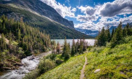
McAfee Knob Panarama
“This hike is packed with great attractions like amazing views, tough climbs and descents, and beautiful sections of trail. The loop features three popular overlooks: McAfee Knob, Dragon’s Tooth, and Tinker Cliffs.” – Hiking Project
Where is the Virginia Triple Crown? (Catawba, near Roanoke)

Why the Triple Crown?
While researching before my 2016 Appalachian Trail hike, I made a list of potential destinations within relatively easy travel distances from Indiana. The closest areas to access the AT from Indiana are Great Smoky Mountain National Park, northern Tennessee, and almost anywhere in Virginia. By 2018 I had already done parts of the Smokies, the Roan Highlands, and the Grayson Highlands. Those were at or near the top of my ‘nearby AT destinations’ wish list. Next on that list was the Virginia Triple Crown near Roanoke. In addition, one of the primary overlooks on the Triple Crown is McAfee Knob, which had been high on my ‘bucket list’ of destinations since I started backpacking. So the Triple Crown it would be in 2018. I had been talking with Bob and Travis about a spring hike that year, and they decided to join me.
Traveling from Indiana to Roanoke
Getting the drive started


The hiking season started with my ill-fated 2018 Red River Gorge hike. Rain and flooding had chased us home early on that trip. Our Red River Gorge plan was to spend three nights in the backcountry. Instead, the hike ended up as one cold, wet, miserable night in the woods, worrying about our camp getting flooded by a rapidly rising stream. I was ‘chompin’ at the bit’ for a second hike. Jaden and Bailey wanted to join me for the Triple Crown ‘redo,’ but they would have to stay home for this one. As I was getting my gear together, they realized our ‘dog pack’ would be split up. I was the recipient of their best ‘we’re not happy’ look. With backpack and suitcase packed and ready, I waited for Bob to arrive. Bob had volunteered to drive us.
Long drive to Roanoke, Virginia
Travis was driving separately and would meet us at our hotel in Roanoke. The long, eight-hour drive started with sunshine, but as we crossed the familiar bridge into West Virginia, the clouds began to build up. Three things were weighing on my mind as we started the trip: (1) bears, (2) crowds, and (3) rain. There had been multiple reports of bears on our route. The Triple Crown is popular with few camping options – would we find places to stay? And a tropical storm was parked off the Atlantic coast near our route. It was forecast to dump inches of rain during the time we would be hiking. Concerns (1) and (2) would wait, but the rain didn’t! As we entered Virginia, it was raining so hard the interstate was flooded in spots.


Due South BBQ


Bob and I talked with Travis as we neared Roanoke. Food takes on new meaning before, during, and after a backpacking trip. In this case, we were all craving barbeque as our ‘last meal’ before the hike. A little Google searching for ‘barbeque along our route’ turned up Due South BBQ, a few miles south of our hotel in Roanoke. It’s a southern-style BBQ joint started by Jaren and Marie March in 2007. They brought their love of barbeque with them from South Carolina. Awards and ‘We Rub Our Butts’ t-shirts hanging on the wall are always a good sign. With our selection of meats, buns, and sauce in hand, we headed for our rendevous with Travis at the hotel. Delicious BBQ smells made self-restraint difficult the last few miles on I-81.

Bob ‘Jumping for Joy’ outside Due South BBQ in Roanoke, Virginia
“Not a local, but this terrific joint is extremely popular with residents. Pulled pork, ribs or chicken the meats were all top notch. Friendly staff and easily accessed off the highway, this is a must-stop for travelers hankering for some tasty, unique vittles in an adorable shack!” – Due South Review
Appalachian Trail Virginia Triple Crown Hike Plan
The Virginia Triple Crown is often done as a 35-mile loop, utilizing the North Mountain Trail after the Appalachian Trail section. The North Mountain Trail received poor reviews. It was overgrown, with few places to camp and absolutely no water. Since we had two cars, we planned to do the Triple Crown as a point-to-point, 3-day, 25-mile hike. One car would be left at our ending point, the Andy Layne Trailhead at the northern terminus. We would then pile in Bob’s car and drive south to the Dragon’s Tooth Trailhead for the start of the hike. Our first milestone would be Dragon’s Tooth, then we’d hike north to the John’s Spring Shelter for night #1. On the second day, we would do McAfee Knob and Tinker Cliffs, then stay the night at Lamberts Meadow Shelter. On the third day, we would return to the car on the Andy Layne Trail.

Day #1 – Appalachian Trail Virginia Triple Crown hike
Raining already to start day #1 of the Triple Crown
There was no period of anticipation on when the rain would arrive. It was already raining when we woke up on the first morning of the hike. The rain wouldn’t stop for 36 hours! After a complimentary continental breakfast at the hotel, we made the short drive to the Andy Layne Trailhead. Fortunately, even though it was raining, the temperatures were relatively warm. And the forecast was that they would stay that way. Hypothermia wasn’t expected to be a problem though we were fully expecting to be soaking wet the entire hike. I donned my Zpacks Vertice rain gear, the packs were transferred into Bob’s vehicle, and we headed south toward the Dragon’s Tooth Trailhead. Foliage was still vibrant green with a springtime appearance.


YouTube Video – Start of day #1 of the Triple Crown
Dragon’s Tooth


From the Dragon’s Tooth Trailhead the hike starts on a blue-blaze trail, not the Appalachian Trail. You’ll connect with the AT 1.7 miles into the 2.5-mile hike to the Tooth. The first part, to the AT, is a relatively tame climb through beautiful woods. However, all of the recent rain made the many stream crossings treacherous. They were flooded and running fast. Once we connected with the Appalachian Trail, the real ‘fun’ began. From that point to the top is a 0.7-mile increasingly steep rock scramble. The last stretch is the ‘best;’ more rock climbing than hiking. Sadly, we did the entire hike ‘in the clouds.’ There were no views at all, either on the hike or at the Tooth. We shrugged it off and decided it gave us a reason to return.

Author on the final rock scramble before Dragon’s Tooth summit
“This was an easy hike for the first 1.8 miles. The last mile was the fun part!. Yes, it is a challenge, and its not for those that are afraid of heights or clumsy. This hike was thrilling, with lots of foot and hand climbing. The view was amazing!” – Crystal L. Review

Dragon’s Tooth summit in the rain
YouTube Video – Dragon’s Tooth Rock Scramble
Northbound on the Appalachian Trail to John’s Spring Shelter
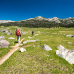
From Dragon’s Tooth, we re-traced our steps to the AT-blue-blaze trail intersection. Bob turned left to the trailhead to get the car. Travis and I continued north on the AT. The plan was to meet Bob at the SR-628 trail crossing near the trailhead. He would drop the packs off (we hiked Dragon’s Tooth packless), and then re-park the car. Rain continued to fall, but it wasn’t unpleasant in the lush, dense, intensely-green forest. The hiking was nice. After we crossed SR-785, we headed uphill to Catawba Mountain through rain-drenched, foggy open fields. Catawba ‘Mountain’ was just a long, tall ridge, and we’d be hiking on it the rest of our hike. In three miles, we crossed busy VA-311, then arrived at John’s Spring Shelter a mile later.


Heading uphill toward Catawba Mountain after the SR-785 crossing
Triple Crown night #1 at John’s Spring Shelter
The rain never stopped the entire day. It would vary from a drizzle to a downpour but fell continuously. There was a parking lot at the Appalachian Trail crossing of VA-311. A small information kiosk was on one side, with a two-foot-wide roof covering it. We gathered under that little dry spot for a short break before tackling the last uphill mile to the shelter. Our motley crew likely looked pathetic standing there, but having just a brief respite from the rain felt great. Arrival at the shelter was joyous. Nothing is better than being warm and dry in a shelter while rain pours around you. Even the shelter mice were dry and happy! Clothes were hung up to dry, but it was pointless in the 100% humidity. Thunderstorms continued all night while we remained cozy and dry. It was a lovely night despite the storms.


John’s Spring Shelter
YouTube Video – To John’s Spring Shelter in the Rain
Day #2 – Appalachian Trail Virginia Triple Crown hike
Still raining to start day #2 of the Triple Crown


Rain, and occasional thunder and lightning, continued the entire night. Fortunately, there wasn’t much wind. As a result, no rain came in through the shelter’s open side. We stayed warm, dry, and comfortable. One last group arrived after dinner. They set up their tent down the hill from the shelter. Alas, their tent appeared like an island in the middle of a pond in the morning. My Canon Vixia G30 lens fogged up… from the inside! Moisture had found its way inside the camera causing internal condensation. I couldn’t clear the lens, so I switched to using my Nikon D810 still camera’s limited video capability. The rain continued to fall and gave no indication of letting up. It was going to be another long, wet day!
McAfee Knob
McAfee Knob is the penultimate overlook on the Appalachian Trail – often called the ‘most photographed spot on the AT.’ Unfortunately, our ‘in the clouds’ hiking continued for our visit to McAfee Knob. The backdrop looked like someone had painted it a uniform, neutral gray. At least the rain had finally stopped, and the temperature was pleasant. We took advantage of what we were sure was a short break from the rain to have lunch. McAfee Knob is undoubtedly a popular place, even in the fog. During our brief stop, about 15 groups came to McAfee Knob. I took my turn sitting on the edge… and didn’t enjoy it one bit! My thoughts were on when that thin rock would finally give way from all the countless visitors. It was a long way down!


Bob on McAfee Knob with clear-day view photoshopped in (actual image in inset)
McAfee Knob to Campbell Shelter


McAfee Knob is located on the high point of the Appalachian Trail in that area. As soon as we left the descent took us through an area of house-size boulders with ‘cracks’ running between them. The trail had been routed straight through the rock ‘canyons.’ It was very cool. Switchbacks took us down quickly, with the trail shrouded in a dense fog. Spooky Scooby Do or Johnny Quest cartoon episodes came to mind in the creepy forest setting. A mile after McAfee Knob we came to the Pig Farm Campsite and Campbell Shelter. There were no other hikers around. I can’t blame them – the woods looked downright scary at that time. There were still many miles to put in on the day so we only stopped briefly before continuing the hike.

Campbell Shelter
Campbell Shelter to Tinker Cliffs
From the Campbell Shelter to Tinker Cliffs, our last Triple Crown landmark is five miles. The terrain and weather remained the same as it had been for the first two days of our hike. Rain, foggy spooky woods, and rolling ridge-top hiking through dense spring-green forests. Somewhere along the way, we transitioned from being on Catawba Mountain to Tinker Mountain. The hiking was nothing like hiking on a mountain – trails were all traversed on a ‘knife edge’ ridge. Exactly when the transition occurred was a mystery. Abandoned farm machinery came into view at the bottom of the descent to Brickey’s Gap, reminding us that the area was farmland at one time. From the Gap, we started the final steep climb to Tinker Cliffs.


Bob on climb from Brickey’s Gap to Tinker Cliffs
Tinker Cliffs


Tinker Cliffs was apparently named for Revolutionary War deserters who hid in the area and made pots and pans. However it got its name, Tinker Cliffs is the least impressive of the Triple Crown overlooks. But, keep in mind, I say that without actually SEEING any of the three overlooks the way they’re meant to be seen. Tinker Cliffs is just an open spot on a cliff along the ridge. Clouds opened up just enough to give us a glimpse of Catawba Creek Valley far below. It didn’t escape us that our car was parked along that creek – we would make that steep hike down tomorrow. Our stop at Tinker Cliffs was short. There was still a mile to hike to Lambert’s Meadow Shelter, and we were ready to have the long day be finished.

Tinker Cliffs with the ‘view’ of Catawba Creek Valley below
“I live by a creek, Tinker Creek, in a valley in Virginia’s Blue Ridge. I think of this house clamped to the side of Tinker Creek as an anchor-hold. It holds me at anchor to the rock bottom of the creek itself… It’s a good place to live; there’s a lot to think about.” – Pilgrim at Tinker Creek, Annie Dillard
Tinker Cliffs to Lambert’s Meadow Shelter
It was a 900 vertical foot descent over one mile from Tinker Cliffs to Lambert’s Meadow Shelter. Halfway to the shelter, we came to Scorched Earth Gap. The Andy Layne Trail turned left off the AT at the Gap. Tomorrow, Andy Layne would take us down to the car. Apparently, Scorched Earth Gap got its name in 1982 from a hiking group that made a wrong turn there and bushwacked all the way down Tinker Mountain. One lady in the group was displeased sufficiently to unleash an epic torrent of profanities that was enough for “the very ground to smoke from her imprecations.” Our pace was fast down the hill, and we soon reached the shelter. The tenting area was flooded, so we set up our tents on a tiny grass area by the shelter.


Tents set up like a puzzle on small strip of grass at Lambert’s Meadow Shelter
Lambert’s Meadow Shelter


Among other claims to fame, Lambert’s Meadow Shelter is known for having a family of giant snakes living under it. Travis REALLY dislikes snakes! It’s also an old shelter with a chewed-up look. The dark, gloomy, and thoroughly wet woods and flooded environment around the area didn’t help. Bob, Travis, and I quickly decided we wouldn’t stay inside the shelter. But shortly after we arrived a father and his two sons showed up. They were happy to take over the shelter. One of the sons had thru-hiked the Appalachian Trail a number of years before. They were a great group to hang out with for the night. Their stories kept us entertained, and the ‘real food’ tacos they graciously shared with us were like food from heaven!

Lambert’s Meadow Shelter
Bob’s ‘Never Give Up’ moose call-assisted campfire
Everything combustible anywhere near Lambert’s Meadow Shelter was beyond wet. ‘Soaked’ doesn’t adequately describe the state of anything that could potentially be used to build a campfire. But Bob was determined to get a campfire going. REALLY determined. The other shelter crew produced some ‘magic’ fire-started that they were willing to donate to the fire ’cause.’ We gathered the driest wood we could find, and Bob went at it. He pulled out a plastic bellows-type straw that made a loud noise, exactly like a moose in distress, whenever he blew threw it. And he blew threw it for the an hour! It was hilarious. But, to Bob’s credit, he got it done. We all thoroughly enjoyed that fire, especially with how wet and cold it was.


Enjoying our hard-earned campfire at Lambert’s Meadow Shelter
YouTube Video – Lambert’s Meadow Shelter
Day #3 – Appalachian Trail Virginia Triple Crown hike
Last morning of the hike at Lambert’s Meadow Shelter
Our fire enjoyment the night before had been cut short. A monstrous thunderstorm rolled in moments before we planned to call it a night. But the timing of the storm worked out well. Our entries into our little tent puzzle didn’t work out nearly as well. Rain was suddenly coming down like a firehose, and maneuvering room around the tents was limited. Travis dove into his REI Quarter Dome tent and broke the vestibule zipper. That zipper was necessary for the structure. As Travis held the tent closed with his hands, we brainstormed a solution from within each shelter. It would have been hilarious if it wasn’t so miserable (for Travis, anyway!). Eventually, he rigged something up with his trekking pole, and we all called it a night.


Lambert’s Meadow Shelter on the last morning of the hike
Steep downhill on the Andy Layne Trail to the car


After a quick breakfast of Dunkin Donuts coffee and cereal, we said our goodbyes to our shelter family and hit the trail. The rain from the previous night had cleared out. Temperatures were already in the 60s, and humidity was off the charts from the recent rain. It was going to be a hot, muggy day. Fortunately, we only had two miles to hike to get back to the Andy Layne Trailhead and car. The first 0.8 miles were steeply and painfully uphill to Scorched Earth Gap. From there, it was a mile and a half, and 1000 vertical feet, down to the car. There always seems to be more bounce in your step when you’re on the ‘home stretch’ of a hike. Soon we were crossing the bridge over Catawba Creek. Shortly after, we arrived at the car.

Andy Layne Trail sign
Conclusion – AT Virginia Triple Crown Backpacking 2017
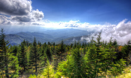
Like my 2017 Smoky Mountains LeConte Lodge hike, there were none of the incredible views the Virginia Triple Crown hike is known for. But just like that 2017 hike, we used the lack of views as a reason to come back another time. Even without views, and with plenty of rain, the Triple Crown was a fantastic hike. Most people don’t know it but disputes with local landowners caused the Appalachian Trail to be re-routed off of Catawba and Tinker Mountains in 1978 and onto the far less scenic North Mountain Trail. Until 1982 you couldn’t even hike on the AT to Dragon’s Tooth, McAfee Knob, and Tinker Cliffs. That history put it all in perspective for me. I was glad we had been able to experience the three famous milestones of the Triple Crown in whatever manner we could.

Group picture in the John’s Spring Shelter on night #1