Great Smoky Mountains National Park (TN) Backpacking – September 2017
Great Smoky Mountains National Park – Sept 2017
30
SEPTEMBER, 2017
Two juveniles were initially charged with starting the fire, though charges were later dropped. Consuming 16,000 acres, killing 14 people, and injuring another 190, the wildfires were the worst natural disaster in Tennessee history. The 2016 Great Smoky Mountains fire, known as the ‘Chimney Tops 2’ fire or simply the Gatlinburg wildfires, would also nearly consume the famous tourist town of Gatlinburg. Over 14 million people visit Gatlinburg annually, and there were concerns that the fires had so damaged Gatlinburg that tourists would stay away. Coincidentally, I would spend Christmas of 2016 in Gatlinburg and see the fire damage close-up. I returned for a Smokies hike in September 2017, thinking fire damage was in the past, and hiking was back to normal. That proved to be a mistake!
Fire Damage – December 2016
My family had a long-scheduled reunion planned in Gatlinburg for Christmas of 2016. We watched the fires in November with a mix of sadness for Gatlinburg and treasured Great Smoky Mountains National Park combined with concern for whether our family vacation would be possible. Frankly, we didn’t see any way the area would recover sufficiently in less than a month for us to travel to Gatlinburg. We were wrong. A month after the fires, Gatlinburg was back in business for visitors, though the area was far from operating at 100%. The fire’s impact had been hit-and-miss. Some areas were utterly devastated, and others completely unscathed. Our family Christmas did happen, and it was a success.


Trip Preparations – Overconfidence leads to poor planning


The 2017 Smokies trip came at the end of an incredible three years of backpacking for me. My physical conditioning, confidence, and backcountry experience were near their peak. In addition, the September trip was my 2nd Smokies hike of 2017. In hindsight, all that led to overconfidence, a lack of discipline, and inadequate preparation. The pre-trip planning mistakes significantly impacted the hike. I’d done a July 2017 Smokies hike with Travis. That trip went flawlessly, aside from some bad weather. But the September Smokies hike was the first where I did all the planning. Smokies permits are done online – no Ranger briefing is required. You must get all the needed trail information yourself, and I failed to do that adequately before my hike.
Dinner and Night Life in Gatlinburg
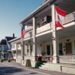
Smoky Mountain Brewery
Travis had opened my eyes to the Smoky Mountain Brewery for dinner the night before our July hike. It treated us well on that trip, so I had no reason to switch it up on this one. I have to say it was a much more lonely experience going there solo. But The Brewery’s Mountain Light Lager in a frosty mug proved to be great company! I made a toast to Travis and the memory of our earlier trip. Dinner was identical to my choice on the prior visit – the Big City Reuben. It was as good as I remembered it. Made with both corned beef and pastrami – it’s piled high with meat. Another deja-vu moment was their way-too-loud trivia game in the bar area. High volume is the norm for bars, but this went a little overboard.


Smoky Mountain Brewery – Gatlinburg, Tennessee
Ole Smoky Moonshine


During our 2016 family Christmas trip we spent time on the Gatlinburg strip, and visited the Ole Smoky Holler. It was my second ‘Holler’ visit of 2016 after Travis and I had stopped by in July. The difference in the ‘vibe’ between the two trips was stark. In July, it was like walking Main Street at Disneyworld – high energy, smiles, laughter, and not a care in the world. After the fires, it felt like the aftermath of a plane crash – sadness and fear, but resiliency too. When I returned for my third visit in September 2017, the mood was somewhere in between. It didn’t feel ‘normal,’ but it was as if you could ‘see normal from here.’ I sensed more energy and joy in the bluegrass band. Like their playing each night was one step closer.

Ole Smoky Moonshine Band Stage with Audience in Rocking Chairs
YouTube Video – Smoky Mountain Brewery and Ole Smoky Holler
Plan For the Hike
The plan for the hike was to do a 3-night, 4-day, 25-mile loop starting at the Clingmans Dome parking lot. I had never visited Clingmans Dome, which initially attracted me to the area. A Google search of ‘best backcountry campsites’ led me to campsite 30. Many considered it the best campsite in the Park. Any Smokies hike has the Appalachian Trail as a tent ‘ridge line’ of sorts. Hiking toward the AT is steeply uphill, and away from it is downhill. My hike would start with 3000 vertical feet of descent over seven miles on day 1. The second day would be a cakewalk – six mostly flat miles to campsite 30. ‘Brutal’ would best describe day 3. Nine all-uphill miles and 3300 vertical feet of gain to the Mount Collins Shelter. If I survived that, the last day would be just 3.5 miles back to Clingmans Dome.

Day #1 – Sept 2017 Great Smoky Mountains NP Hike
Beautiful drive to Clingmans Dome – Empty Parking Lot
My alarm went off early that morning. Based on the experience Travis and I had in July I was concerned parking might be an issue at Clingmans Dome. It wasn’t. There was only one other car in the huge lot. That was actually my first clue that something was amiss with my hike, but that thought didn’t cross my mind at the time. It was a perfect day, the views were stunning, and I was amped for my upcoming solo hike. After a quick pre-hike selfie I started on the short uphill hike to the ‘concrete monstrosity’ that is the Clingmans Dome observation desk. It sits at the highest point on the Appalachian Trail. ‘Something amiss’ clue #2 came moments later. The Clingmans Dome observation deck was closed!


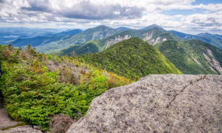
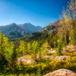
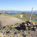
Two breathtaking miles on the Appalachian Trail


Hiking on the Appalachian Trail always feels special to me. That morning on the Appalachian Trail felt otherworldly. I was literally ‘on top of the world.’ Clingmans Dome is the highest point on the AT, and it towers above the surrounding mountains in that area. Clouds filled the valleys far below like cotton balls. There wasn’t a cloud in the sky, and visibility was unlimited. Early fall colors combined with the azure blue sky to create a scene straight from a painting. And I had it all to myself. No other people or hikers were in the parking lot or on the trail. Hmmm..? After two miles, I came to the Goshen Prong Trail. There I met a solitary day hiker. He would be the only person I would see for the next 48 hours.

Goshen Prong Trail intersection on Appalachian Trail – 2.2 miles from Clingmans Dome
Steeply downhill on the Goshen Prong Trail
Instantly after turning onto the Goshen Prong Trail, the hiking changed. From open with breathtaking views to dense jungle-like trails. Surprisingly, the trails were overgrown, and there had clearly been no maintenance for some time. Hmmm… I’m not sure which ‘clue number’ that was, but I was starting to get a strange feeling about the hike. It would only get worse. Halfway down to camp 23, I came to a rare flat spot with a cave. I took advantage and decided to stop for a break. As I was eating my snack I thought I heard a sound coming from the cave. Then I heard a bigger sound from the cave! Discretion being the better part of valor, I moved on (quickly!). I’m not sure what made the sound but I was happy to leave the mystery behind.


Goshen Prong near campsite #23
Campsite #23


About halfway down from the AT, the trail came off the steep slopes and hugged Goshen Prong. The sound of running water was constant. I didn’t know where camp 23 was or what it would look like, so I started scanning for it. Despite my heightened vigilance, I walked right by the side trail to the campsite! Very shortly, though, I saw a camp with a fire ring to my left and realized I had arrived at camp 23. I backtracked and found the entrance. It was marked with a small wooden post 10 feet to the right of the main trail. Easy to miss in that jungle-like setting. Camp 23 was huge! I set up in the back part of the camp. There were four other similar sites. I had the entire area to myself. No other hikers stayed at camp 23 that night.

Camp set up at campsite #23
Day #2 – Sept 2017 Great Smoky Mountains NP Hike
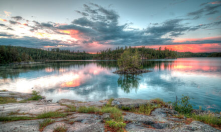
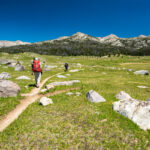
Goshen Prong Trail to Little River Trail
It was a long, lonely night at camp 23. I had hoped to socialize with other campers in a Glacier-like camp setting. That would not be the case. Something just didn’t feel right thus far. When Travis and I had hiked the Smokies in July, throngs of people were on the trails and in the camps. But I didn’t give it much thought that second morning of this hike. I packed quickly and hit the trail early. Sunshine couldn’t penetrate the dense forest canopy, the temperature was in the 40s, and the air felt ‘wet’ from jungle-like humidity. But it was also gorgeous. The Goshen Prong Trail is a spectacular example of stream-side hiking in the National Park. Trees close in above you in an arch-like fashion that feels like you’re in a tunnel. Maintenance was still non-existent, which seemed unusual on what I knew to be a well-traveled trail.


Goshen Prong
YouTube Video – Goshen Prong Trail
Little River Trail – Jungle-like hiking and cause for concern
I came to the Little Little River trail intersection and turned right, heading to campsite 30. Humidity was ridiculous. Every few minutes, the lenses would fog up, forcing me to find something dry to clear them with. Unfortunately, despite the chilly air, every item of clothing I had was soaked with sweat. It was beautiful hiking, but it felt confining, even suffocating. Shortly I came to the junction with the Rough Creek trail I would take tomorrow. I noticed orange tape and a piece of paper on the ground. Flipping the paper over, it said the trail was closed. Huh?! The paper was on the ground off the trail. I didn’t know if the trail was really closed or whether that was an outdated fire notice. And there wasn’t anyone around to ask.


Little River Trail to campsite #30
On to campsite 30 in a daze – Decision time
Continuing past the Rough Creek Trail junction toward campsite 30, I felt like I was in a mild state of shock. The closed (or not?) trail, combined with all of the other ‘hmmm?’ moments on the hike thus far, had finally caught up to me. I felt discombobulated. Making it worse was that I hadn’t seen another person in 30 hours. This hike was in the days before I carried a satellite communication device, and there was no cell coverage. I was on my own! In a fog I pressed on to my intended home for the night. Campsite 30 is isolated. It is at the end of the Little River Trail two miles past Rough Creek. When I arrived at camp 30 I’d never felt so alone. I started setting up camp but started thinking of going back to camp 24, closer to the Rough Creek Trail.


Back to campsite #24
Campsite 24 sits near the Rough Creek Trail junction. I passed it on my way to campsite 30. There was no one there, and no sign anyone had been there for a long time (hmm..?). My permit indicated I was to stay at camp 30, but by this time in the hike, I was confident no one would care if I stayed at camp 24! Camp 30 was a nice spot, but staying there was going to add two miles to my already crazy-long day #3 back up the hill. Plus, it was loud, with water noise from three creeks that joined there. Above all, I was simply starting to feel uncomfortable with the entire situation. Nothing seemed right, and staying at camp 24 just felt ‘better’ to me. Its hard to explain. I packed everything back up and started toward camp 24.


Wet, lonely night at camp 24
Stapled to a big tree in the middle of my camp was a sign saying “Danger – Bear Activity.” Uh… OK! Camp 24 was spread out over a few hundred meters at the junction of Rough Creek and Little River. Everything was wet and muddy, and there were no signs anyone had stayed at that camp for a long time. I found that strange in the Smokies, and it added to my unsettled state. Making things worse, storms rolled in the late afternoon. The forecast had indicated no rain during my hike so I had left my tarp in the car. Big mistake when you hike in the Smokies – it can rain at any time. I rigged up the bathtub floor of my tent as a tarp and took shelter under it. I struggled to get a campfire going and eventually gave up and went to bed.

Camp at campsite #24
Day #3 – Sept 2017 Great Smoky Mountains NP Hike
Brutal, thorny, uphill slog on the Rough Creek Trail


Sleep was tough to come by. Not only had the entire hike felt ‘off’ thus far, but also I had a brutal day of hiking ahead. Staying at camp 24 eased my mind, shaving two miles off the day. But it was still 2500 feet of gain over six miles. Brutal, but something I had done before in Colorado and Glacier. The status of the Rough Creek Trail wasn’t clear. Was it open? And if so, what would trail conditions be? At the Rough Creek Trail junction, I turned left and headed up. Surprisingly, it was in good shape, with evidence of VERY recent maintenance. But the last steep uphill mile was a different story. Gnarly thorn vines had been recently cut down and left on the trail. There was no tread to follow, and the thorns shredded my legs.

Fire damage and recent trail maintenance on Rough Creek Trail
Sugarland Mountain Trail CLOSED! – it all makes sense now
Near the summit, evidence of fire damage was everywhere. So was recent maintenance. The trail was thorny and nasty, but it would have been impassible without someone putting in a TON of effort recently to clear it. As I approached the top, I noticed a sign ahead that made me nervous. Sure enough, it said the Sugarland Mountain Trail was closed – in both directions! I briefly thought about going on anyway, but the state of the Rough Creek Trail forced me to dismiss the idea immediately. That trail was bad, with a ton of recent maintenance. If the Sugarland were closed, with no maintenance, it would be impassible. I had no choice but to head back down. Everything that I had experienced on the hike instantly made perfect sense.


‘Closed Trail’ sign at Rough Creek – Sugarland Mountain Trail junction
YouTube Video – Rough Creek Trail and closed Sugarland Mt Trail
Time for ‘Plan B,’ whatever that is – Back down the Rough Creek Trail


After it sunk in that I had another date with the Rough Creek Trail, I took a few minutes to collect myself and check the map. It soon became clear why the entire hike had seemed like a weird, bad dream. The Sugarland Mountain Trail was the main artery for the Park in that whole area. With it closed, it was impossible to connect any loop hikes. People were simply not backpacking in that area and hadn’t for nearly a year. No maintenance had been done, and trails were overgrown. The painful realization hit me that the difficulties on the hike were entirely my fault. Permits were obtained online with no Ranger briefing. The system wasn’t smart enough to know the hike you intended wasn’t possible. It was up to you to figure that out!
Little River Trail to Elkmont Campground
Once it hit me what a self-inflicted train wreck of a hike I’d created, I put it out of my mind and committed to a new plan. My only option was to head to the Elkmont Campground. That would put me 30 miles from my car, but I’d deal with that when I arrived. The miles flew by on the downhill return trip. I shredded my legs a bit more on the Rough Creek Trail, but once I hit the Little River Trail, my pace increased to four MPH on the smooth downhill tread, and I soon made it to Elkmont. At the campground store, the clerk had a land phone line and a Yellow Pages book (wow!). I hadn’t used one of those in years. Starting at the top of the shuttles and taxis list, I finally found one that would take me back to Clingmans Dome.


Shuttle ride back to Clingmans Dome


Two hours and $125 later, I was on my way back up the mountain to Clingmans Dome. It wasn’t how I expected to get back to the car, but I was ecstatic nonetheless. Before the hike was even finished, I was already chalking it up as a painful but essential learning experience. Backpacking in Great Smoky Mountains National Park differs from any place I’ve hiked that requires a permit. Glacier, Yellowstone, the Sierra, Rocky Mountain National Park, and other permit areas in Colorado all require a face-to-face pre-hike briefing with a Ranger before you hike. Not so in the Smokies. Travis had done all the permit leg work on our earlier Smokies hike. I let my pre-trip planning ‘guard’ down and paid the price.
Conclusion – Sept 2017 Great Smoky Mountains NP hike
My September 2017 Smokies hike did not go as planned, not by a long shot. I had just gone through a two-year period where every hike went smoothly and, more or less, exactly as planned. That period of ‘smooth’ hikes laid the groundwork for what happened on this hike. Simply put, I was overconfident, lazy, and lacked the pre-trip discipline required to ensure a safe and enjoyable hike. Frankly, I was fortunate that the only negative consequences I suffered were minor inconveniences. But I learned some valuable lessons. Never again would I play it as ‘loose’ with pre-trip planning as I had on this one. During a March 2022 Smokies hike, we would return to hike in this area. That was a great hike and served as some redemption for my 2017 experience. The rough 2017 hike gives me a reason to go back and try it again someday.

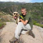
Selfie after the hike at Elkmont Campground