Colorado Overlanding – July 2022
Colorado Overlanding – July 2022
29
JULY, 2022
In late July 2022, Jeremy invited me to go with him on an ‘overlanding’ trip (off-road travel) in southwest Colorado. I jumped at the opportunity. It would be my second overlanding trip after our Land Between the Lakes trip Land Between the Lakes in April 2022. The Colorado trip would be in the Ouray, Telluride, and Silverton areas. That part of Colorado is near-and-dear to me because we took many family camping trips there when the kids were younger. The trip would be 5-days and 4-nights and take us onto some of the most epic overlanding trails that Colorado has to offer.
Meeting Jeremy, the drive to Ouray, and first night camping
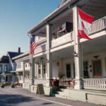
I was already in Colorado at the start of the trip. We had traveled there to see David Gray (yep, really!) in concert at the magnificent Red Rocks amphitheater. Jeremy picked me up at my son, Christian’s, house in Denver, and we began the 385-mile drive to Ouray. Traffic was heavy on I-70 as we headed up into the Rockies. It was a long, slow, and sometimes rainy drive, but we finally made it to Ouray. We didn’t have a reservation for the night, so we first tried the Amphitheater Campground above the town. It was full, but they directed us to Ironton Park, a dispersed camping area 10 miles south of Ouray. Ironton Park was perfect! Jeremy aired down the tires, we got a fire going, and we enjoyed our first night of camping in Colorado.


Bacon, eggs and percolator coffee the first morning

It rained on and off all night, an omen of what we would deal with the entire trip. That first morning was cloudy and gloomy, but Jeremy brightened my spirits with a breakfast of bacon and eggs. Percolator coffee rounded it out. It turned out our first trail, Corkscrew Gulch, started right from Ironton Park. How convenient! We were excited to get started with the overlanding.
Corkscrew Gulch – Overlanding begins
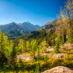
Our introduction to Colorado overlanding would be on Corkscrew Gulch. What a great trail to start on. Oxidation of hematite or iron ore gave the mountains spectacular color. Many consider Corkscrew Gulch to be the most beautiful off-road trail in Colorado. I couldn’t argue with that assessment. The trail started out of Ironton Park and began gently uphill through a forest. Soon we broke out of the forest into a basin between the mountains. The trail then went steeply uphill on a series of switchbacks that were narrow in spots. Jeremy’s Ford Bronco handled it with ease. At the top of the climb, we reached Corkscrew Pass. A right turn at the pass took us very steeply uphill to a saddle with great views in all directions.


The elevation at Corkscrew Pass is 12,244 feet. We stopped to grab a snack and take some pictures. I noticed the package of cashews I had was blown up like a balloon. The cashews must have been packaged much closer to sea level, and the elevation had caused it to expand, almost to the point of popping. It was quite a demonstration of the effects high altitude could have.
Descent from Corkscrew Pass – overlanding to Hurricane Pass
The descent from Corkscrew Pass took us through a beautiful valley in the Uncompahgre National Forest. The deep green of the forest and meadows was in sharp contrast to the red and orange we had seen just a short time ago on the other side of Corkscrew Pass. We passed by a bathroom on the side of the road a short distance from the pass. It was a strange sight out in the middle pristine National Forest but also very convenient. As we started the steep climb up to Hurricane Pass, the road took us past some ruins of mining operations in the area. Progress was slowed by frequent stops to take pictures and capture video of the gorgeous scenery. Soon we reached the top of the climb and Hurricane Pass.


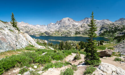
Hurricane Pass and Lake Como


At 12,730 feel Hurricane Pass is even higher in elevation than Corkscrew Pass. The view down the other side, toward sapphire greenish-blue Lake Como, took our breath away. We were just at the beginning of our overlanding adventures, but already we had packed an entire trip’s worth of views into one morning. On the other side of Lake Como, we could see the end of the Poughkeepsie Gulch Trail. If everything went well, we would be driving the Poughkeepsie Gulch Trail and its famous obstacle, ‘The Wall,’ in the next couple of days. After taking some pictures, we started down from Hurricane Pass towards the restored mining town, Animas Forks. From there, we decided to head down to Silverton.
Animas Forks to South Mineral Campground
Our original plan had been to tackle the famous Alpine Loop after we completed Corkscrew Gulch. But our trouble finding a campsite the previous night started me thinking about an alternate plan. We planned to stay at the South Mineral campground a few miles northwest of Silverton. I had stayed at South Mineral many times on family car camping trips. South Mineral is first-come, first-served, which could be good or bad for us. No reservations meant we had as good a chance as anyone at getting a spot. But it also meant the campground would likely be full by early afternoon. I thought our best chance at getting a spot was to arrive late morning when campers had left from the previous night but not yet arrived for the current night.


Passing through Animas Forks quickly (we would be back later) we descended on Country Road 2 towards Silverton. Two miles north of Silverton we took the left turn to South Mineral. Thankfully, my plan worked perfectly. We found the campground nearly empty. We set up camp in site #7 – it would be our home for the next two nights.
Mineral Creek – overlanding on shelf roads
We headed out for more overlanding after getting camp set up and eating lunch. This time we would be taking on a ‘red’ (most difficult) trail, Mineral Creek. From South Mineral, we climbed over Red Mountain Pass. The trailhead for Mineral Creek sits about halfway between Red Mountain Pass and Ouray. As we descended, it started to rain. The rain turned to thunderstorms shortly after starting the trail. It was pouring as we negotiated the sketchy shelf road section (a very narrow area with a steep dropoff). Fortunately, when we reached the difficult ‘rock garden’ section, the rain had stopped. Near the top of the climb, the clouds filled in below us, making for some great pictures. We reached the top successfully, and our second trail was finished.


Poughkeepsie Gulch – seriously difficult overlanding
The most technically difficult trail we would do on the entire trip, Poughkeepsie Gulch, started right at the end of the Mineral Creek trail. The main obstacle on Poughkeepsie Gulch is known as ‘The Wall.’ The name is fitting! At the start of The Wall, a sign warns you, ‘I’d Turn Back if I Were You!’ That got my attention. The Wall is a 40-foot incline with a 25-degree ascent angle. On the left side of it is a 3-foot dropoff that would flip a vehicle sideways if you slid down it. The ascent is in two parts, almost like going up stairs. The main difficulty with the climb is that it goes from a 25-degree i25-degree nearly flat at the top. That turned out to be our undoing.
Jeremy successfully negotiated the climb to the top but bottomed out on the skid plates when the front tires crested the climb and reached the flat. He tried a couple more times to improve the angles but without success. For the first and only time on the trip, we resorted to the winch to get to the top. After The Wall, Jeremy needed a break and let me drive for the first time. I completed the rest of the Poughkeepsie Gulch Trail. What a blast! At the top of Hurricane Pass, we made the left turn down to Silverton in pouring rain, lightning, and thunder. We were happy the storm hadn’t hit us on The Wall.


First night at South Mineral Campground


The view of Lake Como as we passed over Hurricane Pass for the second time that day was surreal. Thus far rain had been part of the trip the entire time, and it would continue until the end. It was the rainiest trip I have ever done in Colorado. Fortunately, the mornings were usually ok, and the rain didn’t stop us from doing anything we planned. Our first night in South Mineral was rainy but pleasant nonetheless. We relaxed under the tarp and later in the shelter of the pine trees. Dinner was fantastic – T-bone steaks and asparagus washed down with ice-cold Coors Light. We completed three trails for the day and spent 10.5 hours in the Bronco. We were both exhausted but thoroughly satisfied.
Breakfast at South Mineral
With Corkscrew Gulch, Mineral Creek, and Poughkeepsie Gulch behind us, the plan for the second day of overlanding was Imogene Pass. We left open the possibility of more after Imogene, but the logistics would make it hard. The Imogene Pass Trail takes about 4 hours and ends in Telluride, on the other side of the mountains from Ouray and Silverton. But we would play it by ear. Breakfast started with some outstanding Hilltop Packs coffee brewed in the percolator. Sadly, there would be no bacon and eggs this morning. Instead, we satisfied ourselves with cereal and ice-cold milk. After breakfast, we packed the Bronco for the day, studied the guidebook to understand what we were in for, and headed up the mountain towards Ouray.


Imogene Pass – Beautiful overlanding
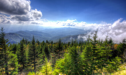
The start of the Imogene Pass Trail is at the south end of Ouray, and it ends in Telluride. The rain had stopped, and we began the climb in the best weather we’d had on the trip. It was sunny, but there were still plenty of clouds—perfect conditions for capturing great pictures. As we neared the pass, the clouds closed in below us but parted often enough to present us with gorgeous views of the trail and surrounding mountains.
Yellow and purple wildflowers were everywhere, adding another splash of color to the magnificent scenery. The trail was steep and narrow in spots, but, unlike yesterday, there was nothing technically challenging to overcome. We stopped briefly at the Pass to take pictures, but the temperature was in the low 40s, and the wind was howling, so we didn’t linger long. As we descended toward Telluride, the mountains took on colors of red and orange, reminiscent of the Corkscrew Gulch Trail.


View of Black Bear Pass from Imogene Pass Trail

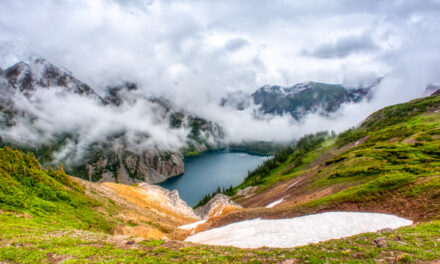
The descent toward Telluride continued, passing through the Social Tunnel and onto a shelf road section more visually stunning than technically challenging. As we approached the city, we rounded a corner and came upon a view of the Black Bear Pass trail descent that we had been told about. We planned to do Black Bear Pass the next day so getting a close view of what we were in for was crucial. We stopped, got out, took pictures, and studied the descent. I’m unsure if it helped or freaked us out more! The scene before us was intimidating. It looked like someone had drawn thin white lines on the face of a sheer cliff, but we knew those ‘lines’ were the road we would have to negotiate. We would be driving down that road the next day if all went well.
Back to South Mineral through Ouray
There is no easy or short way back to Silverton and South Mineral from Telluride. We thought about taking the ‘green’ (easy) off-road trail over Ophir Pass, but that would have taken much longer. Ultimately, we chose the ‘quick’ route (1 hour 45 minutes) through Ouray. That decision was made partly to allow us to get a shower (for $5) at the Ouray Hot Springs Pool and Fitness Center. Bring your towel, though – they don’t rent towels, and to purchase one is $18. We grabbed a great burger at Maggie’s Kitchen in Ouray, did one more climb over Red Mountain Pass, and settled in for another rainy night at South Mineral. It was a late lunch and large, so we settled for simple hot dogs over the fire for dinner.


Black Bear Pass – crazy overlanding on the descent
The following day we packed up and left South Mineral campground. It rained most of the time that we had been in camp, but campsite #7 had treated us well. South Mineral brought back many great memories of previous trips, and we made many new memories on this trip. The plan for today was pretty simple – Black Bear Pass. That trail had been on Jeremy’s mind all week, or more accurately, the final descent down from the Pass. We looked at it from the Imogene Pass Trail yesterday and knew what to expect. Both of us were excited to do it. The turnoff to Black Bear Pass was part way up the drive to Red Mountain Pass, so it only took a few minutes to get there from camp.


Overlanding up to Black Bear Pass
The climb from the trailhead up to Black Bear Pass is scenic and steep in spots but relatively mundane compared to all the trails we had already done. Driving the Black Bear Pass Trail is all about the ‘steps’ and that final descent down to Telluride. As we reached the pass, all that excitement was still ahead. We stopped at the Pass to get some pictures and grab a snack. With our excitement building, we started the descent.


The Steps and switchbacks – extreme overlanding


Immediately after Black Bear Pass, we entered a shelf road area. The road was narrow, with a steep drop-off on the driver’s side. It wasn’t as dramatic as the shelf road stretch on Mineral Creek, but it still got our attention. At one point, we were delayed by marmots crossing the road (I can’t make that up!). Shortly we came to the first significant obstacle on our drive down – The Steps. The Steps are a series of three sharp drops, all seriously off-camber (tilted to the side). If you’re going to have a rollover on the Black Bear Pass Trail, it will be on The Steps. You can go on YouTube and watch some of them!
Jeremy handled The Steps like a pro, using a technique of ‘straightening the curve’ to take out some off-camber aspects. After The Steps, you round a corner and arrive at Ingram Falls. We stopped at the Falls with another group of jeeps we had been traveling with down from the Pass. They were veterans of the Black Bear descent and offered to guide us through the first few switchbacks. There is no doubt about it – the first switchback is intimidating! The road is one jeep-width wide, you have to make a 180-degree turn on the steep grade, and there is a big dropoff inches away. Jeremy used the Bronco’s ‘trail turn assist’ to great effect and made the turn without much drama. Visually it was pretty dramatic, though!


Bridal Veil Falls and the power station

After the first two switchbacks, the excitement on the descent is effectively over. But about halfway down you, come to the Bridal Veil Falls and a power station at the top of the falls. It’s an impressive sight and one that left me thinking about the old series Twin Peaks for some reason. It just had the same sort of look to it that Twin Peaks had.
Alta Lakes Campground – Miserable weather and bailout
After Bridal Veil Falls the trail levels out, and soon, you arrive on the outskirts of Telluride. We planned to stay at the Alta Lakes campground a few miles south of Telluride. The weather had been threatening the whole day and continued to deteriorate as we climbed up to Alta Lakes. Alta Lakes was another first come, first served campsite, so we weren’t sure what we would find. But when we got to Alta Lakes, it was mostly empty. We found a good spot, set up camp, and relaxed on the many sitting logs and rocks in camp.
It was 70degF and pleasant when we arrived at camp, but soon the thunderstorms started rolling in. We set up the tarp ‘just in case.’ As was so often the case on this trip, the tarp became a necessity. The temperature dropped about 30 degrees, the winds picked up to 20+ MPH, and it started raining… hard. The winds were so strong we had trouble keeping the tarp up. It was miserable. I added layers of clothes to stay warm, but eventually, I made my way to the heater in the Bronco. The forecast was for the weather to keep up that way all night. Based on the consistently rainy weather we had the whole trip, we had no reason to doubt the forecast. We decided to bail out and look for a hotel.


Grand Imperial Hotel in Silverton
Deciding to head to a hotel and finding one, especially in prime-time tourist season in Colorado, are two entirely different things! Our initial plan was to find a hotel in Telluride, only a few miles from Alta Lakes. But every hotel in Telluride was full. Same story for Ouray. Even Montrose was completely booked. Just when we were thinking about returning to our miserable campsite at Alta Lakes, I reserved the last available room at the Grand Imperial Hotel in downtown Silverton. Our plan for the last day of overlanding was to do the Alpine Loop. It starts out of Silverton so staying there made a ton of sense logistically. Their website is here.
The Grand Imperial Hotel is like a throwback to 1900 and the silver boom in Silverton. I know it’s not possible, but the lobby décor looks original to 1900! Our stay at the hotel was just what we needed. We took showers, grabbed a pizza from the nearby Avalanche Brewing Company, enjoyed a little Blanton’s in the room, and slept in a real bed for the first time in many days. I slept better than I had the entire trip and awoke feeling rejuvenated.


Breakfast at Kendall Mountain Cafe
Very few things give me as much pleasure on a road trip as a nice bacon and egg breakfast from a local ‘Mom-and-Pop’ restaurant. This morning, breakfast would be found at the Kendall Mountain Cafe on the main drag in Silverton. When we arrived, the restaurant was a few minutes away from opening, and there was already a line of locals waiting to get in – an excellent sign! The coffee was outstanding, as was my traditional breakfast of eggs, bacon, hashbrowns/home-fries, and toast. Between the stay at the Grand Imperial Hotel and breakfast at the Kendall Mountain Cafe, my ‘happy meter’ was pegged on full heading to our last day of overlanding on the Alpine Loop.


Animas Forks


Before starting the Alpine Loop, we stopped at Animas Forks Historic Site. It’s a restored mining town that sits just off the road before the start of the climb to Engineer Pass. The first cabin at Animas Forks was built in 1873, and by 1883 450 people lived in the town containing 30 cabins, a hotel, a general store, a saloon, and a post office. There was a 23-day blizzard that dumped 25 feet of snow on the town in 1884. Mining profits began to decline, and mining operations moved to other areas. By 1920 Animas Forks was a ghost town. Initial stabilization efforts on the buildings were made in 1990. A comprehensive restoration of the buildings was performed in 2013-2014. It is a great place to visit – get there if you can.
Alpine Loop – overlanding to Engineer Pass
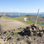
The Alpine Loop and the climb to Engineer Pass started immediately after leaving Animas Forks. Technically, Animas Forks is on the Alpine Loop, as shown on the maps, but the loop begins as soon as you pull out. The Alpine Loop is child’s play compared to all the trails we had done previously. I think my Saab could handle it with ease. Because it isn’t technically challenging, it is very popular. We ran into a steady stream of all sorts of off-road vehicles. But that didn’t take away from the fantastic views and scenery. It is all above the treeline up to Engineer Pass, so the views go on as far as the eye can see. We reached the top of the climb and took a left turn to a fantastic viewpoint known as Odom Point.


Odom Point


There was a crowd of jeeps at the top of the climb, but none took the left turn out to Odom Point. They were missing out! We had Odom Point to ourselves. The views in all directions were incredible. After parking the Bronco, we got out to take in the sights and capture some video and stills. We took our time. Jeremy and I were both starting to sense that the trip was coming to an end, and we wanted to make it last as long as possible. Jeremy took a moment to place an ‘All Things Outdoors’ (Jeremy’s YouTube channel) sticker on the Odom Point sign. It seems to be some tradition because all these markers throughout the trip were covered with stickers. We returned to the Bronco and started the short descent to Engineer Pass.
Engineer Pass
That’s right, I said ‘descent’ to Engineer Pass. You don’t often descend to a pass, but the top of the climb and Odom Point are a bit higher than the flat shelf-like area of Engineer Pass. Strange! There was a crowd gathered at the pass when we arrived. The views looking in both directions from the pass were excellent. To the west, orange and red colors dominated the mountains; to the east, it was all green. In that regard, it was similar to Corkscrew Pass. We took pictures and ‘compared notes’ with the Jeep owners at the pass. Soon it was time to head down toward Lake City and start the long drive back to Indiana. At the beginning of the descent, we met a mountain biker going up – his first words were ‘how do you like your Bronco?’.


One last stop – the Broken Dam


Jeremy had told me about a ‘broken dam’ site he discovered during his pre-trip research. It sounded like an excellent stop, but the only problem was he had no idea where it was on the Alpine Loop. We hadn’t seen it and suspected it might be on the south side of the Loop. But shortly before we came into Lake City, we saw cars gathered on the side of the road. It was the broken dam site. I found out from others that this was the ghost town of Henson. It was established when gold was found in the area in 1873. We made one final picture stop at a scenic canyon and then drove into Lake City. Our last lunch on the trip was some fine barbeque at the Lake City Brewing Company. After lunch, we started the long drive home.
Conclusion – Colorado Overlanding
I didn’t know what to expect going into the trip. My earlier jeep experience on the Alpine Loop made me realize we would have a blast and see some fantastic scenery. But this trip far exceeded any expectations I had. The scenery and views were nonstop and the finest I’d seen in Colorado. The driving was both more challenging and fun than I could have imagined. It was also surprisingly exhausting, both physically and mentally. I certainly wouldn’t have expected that, knowing we would be riding around in a vehicle.
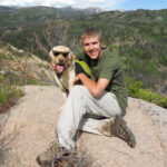
The non-stop rain was the only bummer on the trip. It was the rainiest and consistently lousy weather I have experienced on my many Colorado trips. But it didn’t stop us from doing any of the trails that we had planned to do. In the end, it was a fantastic trip. Jeremy is the perfect travel partner, and I have to thank him for making the trip possible for me. I can’t wait for the next one!

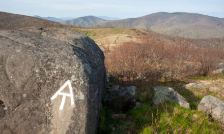
Group shot at Engineer Pass on the Alpine Loop